IMAGES TAKEN NEAR TO
Sydney Grove, NOTTINGHAM, NG12 2BH
Introduction
This page details the photographs taken nearby to Sydney Grove, NG12 2BH by members of the Geograph project.
The Geograph project started in 2005 with the aim of publishing, organising and preserving representative images for every square kilometre of Great Britain, Ireland and the Isle of Man.

There are currently over 7.5m images from over14,400 individuals and you can help contribute to the project by visiting https://www.geograph.org.uk
Image Map
Images are licensed for reuse under creativecommons.org/licenses/by-sa/2.0
Notes
- Clicking on the map will re-center to the selected point.
- The higher the marker number, the further away the image location is from the centre of the postcode.
Image Listing (43 Images Found)
Images are licensed for reuse under creativecommons.org/licenses/by-sa/2.0
Image
Details
Distance
3
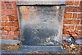
Benchmark on Nottingham Road wall pier
Ordnance Survey cut mark benchmark described on the Bench Mark Database at https://www.bench-marks.org.uk/bm99464
Image: © Roger Templeman
Taken: 10 Sep 2018
0.13 miles
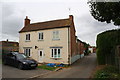
4
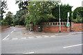
Junction of Nottingham Road and Yew Tree Close
There is an OS benchmark Image on the wall pier right of the bus stop sign
Image: © Roger Templeman
Taken: 10 Sep 2018
0.14 miles
5
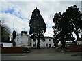
Radcliffe Hall
One of the few surviving buildings of pre-suburban Radcliffe https://historicengland.org.uk/listing/the-list/list-entry/1039589
The premises of the Royal British Legion.
Image: © Jonathan Thacker
Taken: 16 Apr 2021
0.16 miles

8
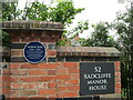
Plaque to George Parr
George Parr 1826-1891 Nottinghamshire & All England cricketer born and lived at The Manor House (Radcliffe on Trent)
Image: © El Loco
Taken: 4 Jun 2021
0.18 miles
9
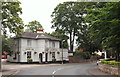
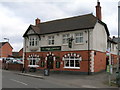
Radcliffe-on-Trent, Notts.
Originally called The White Hart, the Grade II-listed "Manvers Arms" pub sits opposite St Mary's Church on Main Street. This is the view seen by individuals entering Radcliffe from Nottingham Road (a 'B' road) that has branched off the A62 (Gamston area). Each succeeding member of the aristocratic Manvers family was the owner of nearly all the local land, the lord of the manor and the patron of the St Mary's Church 'living'.
Image: © David Hallam-Jones
Taken: 20 Jul 2013
0.18 miles
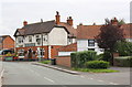
10
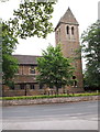
Radcliffe-on-Trent, Notts.
St Mary's Church, Main Street seen from the car park entrance at the side of "The Manvers Arms" pub.
Image: © David Hallam-Jones
Taken: 20 Jul 2013
0.19 miles