IMAGES TAKEN NEAR TO
Manor Lane, NOTTINGHAM, NG12 1EQ
Introduction
This page details the photographs taken nearby to Manor Lane, NG12 1EQ by members of the Geograph project.
The Geograph project started in 2005 with the aim of publishing, organising and preserving representative images for every square kilometre of Great Britain, Ireland and the Isle of Man.

There are currently over 7.5m images from over14,400 individuals and you can help contribute to the project by visiting https://www.geograph.org.uk
Image Map
Images are licensed for reuse under creativecommons.org/licenses/by-sa/2.0
Notes
- Clicking on the map will re-center to the selected point.
- The higher the marker number, the further away the image location is from the centre of the postcode.
Image Listing (62 Images Found)
Images are licensed for reuse under creativecommons.org/licenses/by-sa/2.0
Image
Details
Distance
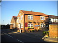
1
The Earl of Chesterfield Public House in Shelford
Image: © Jonathan Clitheroe
Taken: 5 Oct 2024
0.03 miles
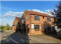
2
Earl of Chesterfield, Shelford
A pub, with attached restaurant, on Manor Lane at the northern edge of the village.
Image: © Richard Vince
Taken: 26 Aug 2013
0.03 miles
3
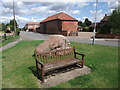
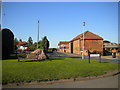
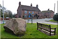
Seat and millennium stone on road through Shelford
The stone is a rather incongruous lump of granite, inscribed 'Shelford 2000'. Waterlane Farm behind, with the date 1834 in the brickwork, is one of several farms in the area belonging to the Crown Estate.
Image: © Tim Heaton
Taken: 24 Aug 2008
0.04 miles
5
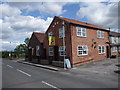
The Earl of Chesterfield, Shelford
Philip Stanhope of Shelford was created first Earl of Chesterfield by Charles I in 1628. Shelford's support of the Royalists led to a significant battle at Shelford Manor in the Civil War. http://www.nottshistory.org.uk/articles/tts/tts1903/summer/shelford4.htm
Image: © Tim Heaton
Taken: 24 Aug 2008
0.05 miles
6
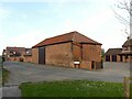
Barn at Water Farm, Shelford
Probably early 19th century, with lean-to extension dated 1834, Listed Grade II. The hipped roof is characteristic of the farms in the village http://www.geograph.org.uk/photo/6803831 http://www.geograph.org.uk/photo/6803733 , all of which formed part of the estate of the Stanhope family, later Earls of Carnarvon.
Image: © Alan Murray-Rust
Taken: 4 Apr 2021
0.06 miles
7
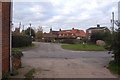
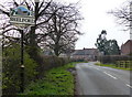
Manor Lane, Shelford
The main road out of the village to the north, seen from Church Street. Note the rather haphazard dating of the barn at Water Lane Farm in bricks.
Image: © Richard Vince
Taken: 26 Aug 2013
0.07 miles
8
Millennium stone on a small green in Shelford
At the junction of Main Lane, Church Street, and Waterfurrows Lane.
Image: © Mat Fascione
Taken: 12 Mar 2016
0.07 miles
9

It's the Leaving of Shelford
Continuing on the Trent Valley Way
Image: © Peter Barr
Taken: 4 Mar 2009
0.07 miles