IMAGES TAKEN NEAR TO
Kayes Walk, NOTTINGHAM, NG1 1PY
Introduction
This page details the photographs taken nearby to Kayes Walk, NG1 1PY by members of the Geograph project.
The Geograph project started in 2005 with the aim of publishing, organising and preserving representative images for every square kilometre of Great Britain, Ireland and the Isle of Man.

There are currently over 7.5m images from over14,400 individuals and you can help contribute to the project by visiting https://www.geograph.org.uk
Image Map
Images are licensed for reuse under creativecommons.org/licenses/by-sa/2.0
Notes
- Clicking on the map will re-center to the selected point.
- The higher the marker number, the further away the image location is from the centre of the postcode.
Image Listing (1696 Images Found)
Images are licensed for reuse under creativecommons.org/licenses/by-sa/2.0
Image
Details
Distance
1

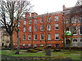
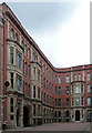
Kayes Walk
In the Lace Market area of Nottingham. A scene typical of the district. The trees on the right are within the churchyard of St Mary's.
Image: © David Lally
Taken: 7 Nov 2009
0.01 miles
2
Lace buildings on Kayes Walk, Nottingham
Image: © Andrew Abbott
Taken: 1 Apr 2010
0.01 miles
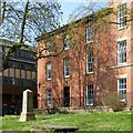
3
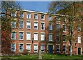
3 & 4 Kaye's Walk, Nottingham
Warehouse, now offices. Mid C19, restored c1991 following a fire. Listed Grade II.
Image: © Alan Murray-Rust
Taken: 1 Apr 2019
0.01 miles
4
Lace building on Kayes Walk, Nottingham
Image: © Andrew Abbott
Taken: 1 Apr 2010
0.01 miles
5
The Lace Market: Kayes Walk
Grade II listed lace warehouses north of St Mary's Church. The 18th-century churchyard walls, gates and railings are also Grade II listed. The picture was taken against the light on the bright morning of Good Friday.
Image: © John Sutton
Taken: 15 Apr 2022
0.01 miles
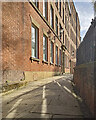
6
8-14 Broadway, Nottingham
The old lace warehouses in this area are among the best works of local architect Thomas Chambers Hine. Handsome orangey-red brick, stone quoins and oriels with decorative tracery. The motif of slender stone hoodmoulds was adopted by other architects in the area. These were built in 1855-56. All grade II listed.
Now in a variety of uses (Image]).
Image: © Stephen Richards
Taken: 18 Jun 2012
0.01 miles
7
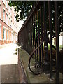
Georgian Railings, St. Mary's Church, High Pavement
Image: © Andrew Abbott
Taken: 5 Jul 2009
0.01 miles
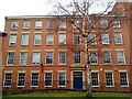
8
5 Kaye's Walk, Nottingham
One of a pair of housesbuilt as a unit with 49 St Mary's Gate https://www.geograph.org.uk/photo/3398364 . Early 19th century, restored late 20th century as offices. Listed Grade II.
Image: © Alan Murray-Rust
Taken: 1 Apr 2019
0.01 miles
9
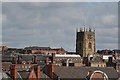
St Mary's Church
The principal parish church of the City rises above the roofs of the City Centre. This view is from the top of the multi-storey car park near Nottingham Station
Image: © Alan Murray-Rust
Taken: 21 Mar 2008
0.01 miles
10
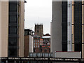
Nottingham ancient and modern
St Mary's church glimpsed between modern developments (Jurys Inn on the right) in a photograph taken from London Road railway bridge.
Image: © John Sutton
Taken: 16 Jul 2009
0.01 miles