IMAGES TAKEN NEAR TO
Plumptre Square, NOTTINGHAM, NG1 1JF
Introduction
This page details the photographs taken nearby to Plumptre Square, NG1 1JF by members of the Geograph project.
The Geograph project started in 2005 with the aim of publishing, organising and preserving representative images for every square kilometre of Great Britain, Ireland and the Isle of Man.

There are currently over 7.5m images from over14,400 individuals and you can help contribute to the project by visiting https://www.geograph.org.uk
Image Map
Images are licensed for reuse under creativecommons.org/licenses/by-sa/2.0
Notes
- Clicking on the map will re-center to the selected point.
- The higher the marker number, the further away the image location is from the centre of the postcode.
Image Listing (1115 Images Found)
Images are licensed for reuse under creativecommons.org/licenses/by-sa/2.0
Image
Details
Distance
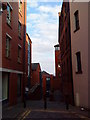
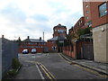
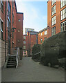
1
Down Short Stairs
Looking towards the bottom of Malin Hill on a sunny August afternoon.
Image: © John Sutton
Taken: 8 Aug 2016
0.01 miles
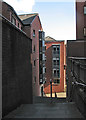
2
Near the bottom of Malin Hill
Malin Hill is an ancient thoroughfare running diagonally down the face of the sandstone bluff on which The Lace Market (the centre of the Saxon burgh) stands. The buildings at this end are relatively recent.
Image: © John Sutton
Taken: 8 Aug 2016
0.01 miles
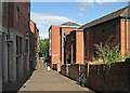
3
A stroll round Nottingham City Centre (22)
Pemberton Street
Image: © Basher Eyre
Taken: 2 Dec 2018
0.01 miles
4

A stroll round Nottingham City Centre (23)
Window in Pemberton Street
Image: © Basher Eyre
Taken: 2 Dec 2018
0.02 miles
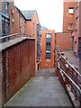
5
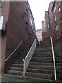
A stroll round Nottingham City Centre (24)
Looking from Pemberton Street up Short Stairs
Image: © Basher Eyre
Taken: 2 Dec 2018
0.02 miles
6
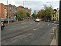
Hollow Stone
A busy three lane one-way road. Part of Nottingham's inner ring road. This heads north into the city centre as the A6008. The outward - southbound - route is by Lower Parliament Street to the east.
Image: © David Lally
Taken: 5 May 2015
0.02 miles
7
Scaffolding on Malin Hill ? 2
Refurbishment work on a large scale, see also https://www.geograph.org.uk/photo/7294699 . The view also shows the sandstone cliffs above which the town of Nottingham developed.
Image: © Alan Murray-Rust
Taken: 23 Sep 2022
0.02 miles
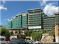
8
Chardlace Walk
The Saxon burgh which became Nottingham developed at the top of a sandstone cliff which overlooked the meadows north of the River Trent (and at that time the course of the River Leen, a tributary of the Trent, since culverted and diverted). This recent development at the base of the cliff, between Hollowstone and Malin Hill (ahead) makes a feature of the sandstone outcrop on the right.
Image: © John Sutton
Taken: 22 Sep 2021
0.02 miles