IMAGES TAKEN NEAR TO
NG1 1JD
Introduction
This page details the photographs taken nearby to NG1 1JD by members of the Geograph project.
The Geograph project started in 2005 with the aim of publishing, organising and preserving representative images for every square kilometre of Great Britain, Ireland and the Isle of Man.

There are currently over 7.5m images from over14,400 individuals and you can help contribute to the project by visiting https://www.geograph.org.uk
Image Map
Images are licensed for reuse under creativecommons.org/licenses/by-sa/2.0
Notes
- Clicking on the map will re-center to the selected point.
- The higher the marker number, the further away the image location is from the centre of the postcode.
Image Listing (1345 Images Found)
Images are licensed for reuse under creativecommons.org/licenses/by-sa/2.0
Image
Details
Distance
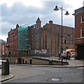
2
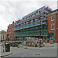
Taking shape on Short Hill
A view from the corner of Stoney Street and Hollowstone, taken on a cloudy August morning.
Earlier images of this building project: Image] (July 2019) and Image] (September 2019).
Image: © John Sutton
Taken: 25 Aug 2021
0.00 miles
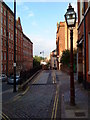
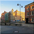
4
The south end of Stoney Street
With the last few buildings on High Pavement at the end and the corner of St Mary's churchyard on the right.
Image: © David Lally
Taken: 29 Oct 2011
0.01 miles
5
A building site on Short Hill
An open space off Short Hill, a car park for many years, is to be the site of student flats. The picture was taken against the light from the corner of Stoney Street. Hollowstone (or Hollow Stone) slopes down to the left.
Image: © John Sutton
Taken: 1 Jul 2019
0.01 miles
6
The Lace Market: a building site on Short Hill
Flats are going up on a space recently used as a car park. For comparison, see Image], taken two months before.
Image: © John Sutton
Taken: 17 Sep 2019
0.01 miles
7
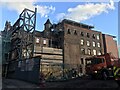
Trivett Square construction, Short Hill
Image: © Bryn Holmes
Taken: 18 Nov 2019
0.01 miles
8
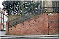
St Mary's - retaining wall
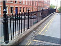
At the junction of Stoney Street, High Pavement and Hollow Stone.
Image: © David Lally
Taken: 25 Feb 2011
0.01 miles
9
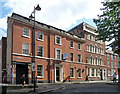
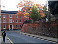
54-56 High Pavement, Nottingham
No. 56, formerly St Mary's vicarage, is a stately five-bay mid-Georgian house, of broad proportions, with some later alterations made when it was converted into a lace warehouse in the C19th. Grade II listed.
No. 54, also mid-Georgian, has caught Venetian window disease from nearby Image], although here they are mixed with Diocletian windows and normal ones. Grade II listed.
Image: © Stephen Richards
Taken: 18 Jun 2012
0.01 miles
10
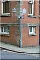
Bench mark, corner of Stoney Street
Typical brick and stone construction of one of the many former lace factories in this part of Nottingham, with the bench mark visible on the left hand face of the angle. Also visible are a pair of the attractive cast street nameplates introduced in recent years as part of the refurbishment of the Lace Market area.
Image: © Alan Murray-Rust
Taken: 17 May 2010
0.01 miles