IMAGES TAKEN NEAR TO
Short Stairs, NOTTINGHAM, NG1 1JA
Introduction
This page details the photographs taken nearby to Short Stairs, NG1 1JA by members of the Geograph project.
The Geograph project started in 2005 with the aim of publishing, organising and preserving representative images for every square kilometre of Great Britain, Ireland and the Isle of Man.

There are currently over 7.5m images from over14,400 individuals and you can help contribute to the project by visiting https://www.geograph.org.uk
Image Map
Images are licensed for reuse under creativecommons.org/licenses/by-sa/2.0
Notes
- Clicking on the map will re-center to the selected point.
- The higher the marker number, the further away the image location is from the centre of the postcode.
Image Listing (1151 Images Found)
Images are licensed for reuse under creativecommons.org/licenses/by-sa/2.0
Image
Details
Distance
1
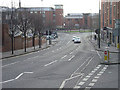
Hollowstone
The street gets its name from the fact that it was originally hollowed out of the Bunter sandstone on which Nottingham stands. Behind the photographer the outcropping rock with a number of incised caves is still exposed.
Image: © Alan Murray-Rust
Taken: 27 Jan 2008
0.01 miles
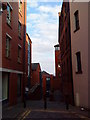
4
Up Short Stairs
Looking towards Short Hill and Hollowstone on a sunny August afternoon.
Image: © John Sutton
Taken: 8 Aug 2016
0.01 miles
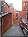
5
Chardlace Walk
The Saxon burgh which became Nottingham developed at the top of a sandstone cliff which overlooked the meadows north of the River Trent (and at that time the course of the River Leen, a tributary of the Trent, since culverted and diverted). This recent development at the base of the cliff, between Hollowstone and Malin Hill (ahead) makes a feature of the sandstone outcrop on the right.
Image: © John Sutton
Taken: 22 Sep 2021
0.01 miles
7
Junction of Hollowstone and Bellar Gate
Image: © Andrew Abbott
Taken: 12 Jun 2010
0.02 miles
8
Hollowstone: cave entrances
The iron gates to the left are the entrances to caves. From the mid 18th century, Hollowstone became the main route out of the city to the east, and it was twice widened. For its history, see http://www.nottshistory.org.uk/articles/tts/tts1927/itinerary1927p1.htm .
Image: © John Sutton
Taken: 30 Apr 2013
0.02 miles
10
High Pavement, Hollowstone and Sneinton on a June evening
At quarter to nine on a sunny June evening the narrow streets of The Lace Market were in shadow, but the setting sun lit Sneinton and the hillier eastern side of the city.
Image: © John Sutton
Taken: 3 Jun 2015
0.02 miles