IMAGES TAKEN NEAR TO
Harnett Close, NOTTINGHAM, NG1 1GX
Introduction
This page details the photographs taken nearby to Harnett Close, NG1 1GX by members of the Geograph project.
The Geograph project started in 2005 with the aim of publishing, organising and preserving representative images for every square kilometre of Great Britain, Ireland and the Isle of Man.

There are currently over 7.5m images from over14,400 individuals and you can help contribute to the project by visiting https://www.geograph.org.uk
Image Map
Images are licensed for reuse under creativecommons.org/licenses/by-sa/2.0
Notes
- Clicking on the map will re-center to the selected point.
- The higher the marker number, the further away the image location is from the centre of the postcode.
Image Listing (1417 Images Found)
Images are licensed for reuse under creativecommons.org/licenses/by-sa/2.0
Image
Details
Distance
1
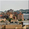
View from the Castle
The view east over Nottingham towards the windmill Image at Sneinton in SK5839
Image: © Gerald England
Taken: 25 Sep 2003
0.01 miles
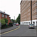
2
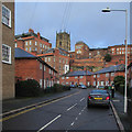
Cliff Road
Council houses under the sandstone cliff on which The Lace Market stands and an inky sky on a November morning.
Image: © John Sutton
Taken: 13 Nov 2015
0.02 miles
3
Cliff Road
The original Saxon burgh from which Nottingham developed was built on the sandstone bluff on which St Mary's Church and the Lace Market district now stand. The council houses of Cliff Road, hemmed in by the sandstone cliff and huge warehouses, were built on the site of one of the city's most notorious slum areas, Narrow Marsh.
Image: © John Sutton
Taken: 24 Aug 2015
0.02 miles
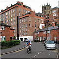
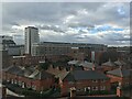
4
Over Narrow Marsh
A morning view from the corner of a car park off Short Hill in the Lace Market. Malin Hill runs down between the buildings on the extreme right and below the parapet in the foreground. Below the sandstone bluff on which the Lace Market stands are the council houses of the Cliff Road Estate, built after the slums of Narrow Marsh were cleared in the 1930s.
Image: © John Sutton
Taken: 30 Apr 2013
0.03 miles
5
Along Cliff Road
Before the council houses on the left were built, this was Narrow Marsh, one of Nottingham's worst slums.
Image: © John Sutton
Taken: 24 Aug 2015
0.03 miles
7
Over Narrow Marsh
A spring-morning view from Malin Hill. The roofs in the foreground are of houses on Cliff Road. The NET tramway crosses the picture on the right, on the alignment of the old Great Central Railway.
Image: © John Sutton
Taken: 11 Apr 2016
0.03 miles
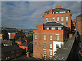
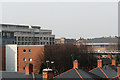
8
Leenside and the Lace Market
Leenside and the Lace Market from Canal Street, with a view of the tower of St. Mary's Church.
Image: © Andrew Abbott
Taken: 21 Mar 2010
0.03 miles
9
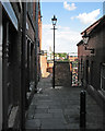
The top of Malin Hill
Sunlight and shadow on an August afternoon. Malin Hill is an ancient - and at its top end narrow - thoroughfare running diagonally down the face of the sandstone bluff on which The Lace Market (the centre of the Saxon burgh) stands.
Image: © John Sutton
Taken: 8 Aug 2016
0.03 miles
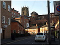
10
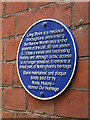
Plaque at top of Long Stairs
Sadly the gate at the top of Long Stairs leading from Commerce Square remains locked. Plaque is at top of Long Stairs just behind the gate on right wall as you look down. Hopefully at some point the Stairs can be fully open and the ancient right of way restored.
Image: © El Loco
Taken: 2 Jan 2021
0.03 miles