IMAGES TAKEN NEAR TO
Cliff Road, NOTTINGHAM, NG1 1GW
Introduction
This page details the photographs taken nearby to Cliff Road, NG1 1GW by members of the Geograph project.
The Geograph project started in 2005 with the aim of publishing, organising and preserving representative images for every square kilometre of Great Britain, Ireland and the Isle of Man.

There are currently over 7.5m images from over14,400 individuals and you can help contribute to the project by visiting https://www.geograph.org.uk
Image Map
Images are licensed for reuse under creativecommons.org/licenses/by-sa/2.0
Notes
- Clicking on the map will re-center to the selected point.
- The higher the marker number, the further away the image location is from the centre of the postcode.
Image Listing (1350 Images Found)
Images are licensed for reuse under creativecommons.org/licenses/by-sa/2.0
Image
Details
Distance
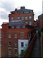
1
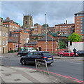
Cliff Road
Council houses under the sandstone cliff on which The Lace Market stands and an inky sky on a November morning.
Image: © John Sutton
Taken: 13 Nov 2015
0.00 miles
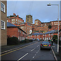
3
Cliff Road
The original Saxon burgh from which Nottingham developed was built on the sandstone bluff on which St Mary's Church and the Lace Market district now stand. The council houses of Cliff Road, hemmed in by the sandstone cliff and huge warehouses, were built on the site of one of the city's most notorious slum areas, Narrow Marsh.
Image: © John Sutton
Taken: 24 Aug 2015
0.02 miles
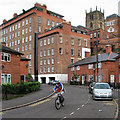
4
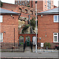
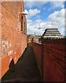
The cliff behind Cliff Road
The original Saxon burgh from which Nottingham developed was built on the sandstone bluff on which St Mary's Church and the Lace Market district now stand. The council houses of Cliff Road, hemmed in by the sandstone cliff and huge warehouses, were built on the site of one of the city's most notorious slum areas, Narrow Marsh. The diagonal brick wall at eaves level marks Malin Hill, an alley linking High Pavement and Bellar Gate.
Image: © John Sutton
Taken: 24 Aug 2015
0.02 miles
5
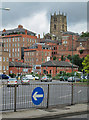
St Mary's Church from London Road
A view of the southern edge of The Lace Market taken from the roundabout where London Road, Canal Street and Lower Parliament Street meet.
Image: © John Sutton
Taken: 15 Jun 2013
0.02 miles
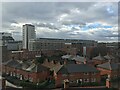
6
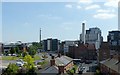
View from Malin Hill
Only possible by holding a camera high above one's head, due to the high wall bounding Malin Hill http://www.geograph.org.uk/photo/5429876. The two chimneys are (left) the Eastcroft incinerator http://www.geograph.org.uk/photo/822360 and (right) the former Boots Company power station now operated together as Enviroenergy providing electricity and district heating.
Image: © Alan Murray-Rust
Taken: 26 May 2017
0.02 miles
8
Canal Street to The Lace Market
The Saxon burgh which became Nottingham was established on the sandstone bluff which is now The Lace Market and the site of St Mary's Church. Above the rooftops of Cliff Road a crane is at work on the site shown in Image], taken a little later on the same morning.
Image: © John Sutton
Taken: 1 Jul 2019
0.02 miles
9
Down Malin Hill
A steep and ancient path on the face of the sandstone bluff on which Anglo-Saxon Nottingham developed. It leads from Commerce Square in The Lace Market down to Bellar Gate and London Road.
Image: © John Sutton
Taken: 9 Sep 2017
0.02 miles