IMAGES TAKEN NEAR TO
Pennyfoot Street, NOTTINGHAM, NG1 1GF
Introduction
This page details the photographs taken nearby to Pennyfoot Street, NG1 1GF by members of the Geograph project.
The Geograph project started in 2005 with the aim of publishing, organising and preserving representative images for every square kilometre of Great Britain, Ireland and the Isle of Man.

There are currently over 7.5m images from over14,400 individuals and you can help contribute to the project by visiting https://www.geograph.org.uk
Image Map
Images are licensed for reuse under creativecommons.org/licenses/by-sa/2.0
Notes
- Clicking on the map will re-center to the selected point.
- The higher the marker number, the further away the image location is from the centre of the postcode.
Image Listing (579 Images Found)
Images are licensed for reuse under creativecommons.org/licenses/by-sa/2.0
Image
Details
Distance
1
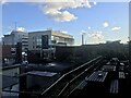
Sneinton: over the rooftops
A foreshortened zoom view towards the city centre from the entrance to William Booth Primary School, with the tower of St Mary's Church in the Lace Market on the right.
Image: © John Sutton
Taken: 13 Apr 2016
0.01 miles

6
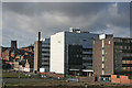
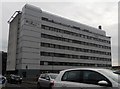
Biocity Nottingham
Pharmaceutical research firm, formerly part of the Boots Company.
Image: © Alan Murray-Rust
Taken: 21 Jan 2007
0.05 miles
8
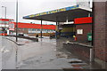
Car wash on Lower Parliament Street
There is an OS benchmark Image on the brick wall of #243 Lower Parliament on the brick wall on the right hand side of the image, just right of the small grey electric caninet
Image: © Roger Templeman
Taken: 9 Apr 2012
0.05 miles
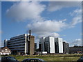
9
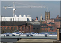
Nottingham skyline from Sneinton
Nottingham Castle is on the skyline on the left, St Mary's Church in The Lace Market in the centre and Biocity to the right in this view from the edge of the Newark Crescent estate which stands on the elevated site of the Manvers Street Goods Depot, built by the London & North Western Railway. Image] shows some of the huge retaining walls which supported the railway yard. The railway line from Grantham to Nottingham Victoria once snaked across the waste land in the foreground on an iron viaduct and brick arches, with the Corporation gas works to its left and Victorian factories to the right.
Image: © John Sutton
Taken: 16 May 2016
0.05 miles
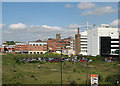
10

Benchmark on #243 Lower Parliament Street
Ordnance Survey cut mark benchmark described on the Bench Mark Database at http://www.bench-marks.org.uk/bm42417
Image: © Roger Templeman
Taken: 9 Apr 2012
0.05 miles