IMAGES TAKEN NEAR TO
Fishergate, NOTTINGHAM, NG1 1FY
Introduction
This page details the photographs taken nearby to Fishergate, NG1 1FY by members of the Geograph project.
The Geograph project started in 2005 with the aim of publishing, organising and preserving representative images for every square kilometre of Great Britain, Ireland and the Isle of Man.

There are currently over 7.5m images from over14,400 individuals and you can help contribute to the project by visiting https://www.geograph.org.uk
Image Map
Images are licensed for reuse under creativecommons.org/licenses/by-sa/2.0
Notes
- Clicking on the map will re-center to the selected point.
- The higher the marker number, the further away the image location is from the centre of the postcode.
Image Listing (856 Images Found)
Images are licensed for reuse under creativecommons.org/licenses/by-sa/2.0
Image
Details
Distance
2
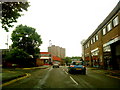
Lower Parliament Street and Biocity
Traffic approaching the London Road and Canal Street roundabouts. Image] shows the building in the centre being put up in 2016.
Image: © John Sutton
Taken: 23 Jul 2018
0.03 miles
3
Plumtre Hospital, now 'character offices'
There should be an Ordnance Survey cut mark benchmark, http://www.bench-marks.org.uk/bm34316 on the front of the jut left of the door, but the building has been redered concealling the mark.
Image: © Roger Templeman
Taken: 1 Apr 2013
0.03 miles
4
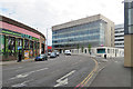
The south end of Lower Parliament Street
The building in the centre middle distance is shown under construction in Image
Image: © John Sutton
Taken: 31 Aug 2017
0.03 miles
5
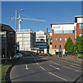
Lower Parliament Street on a May evening
The crane is on the site of a new building on the Biocity complex. For more about Biocity, see http://www.biocity.co.uk/news/nottingham/2015/nottingham-gets-grow-ahead-for-new-30m-life-science-facility .
Image: © John Sutton
Taken: 16 May 2016
0.03 miles
6

Benchmark on #243 Lower Parliament Street
Ordnance Survey cut mark benchmark described on the Bench Mark Database at http://www.bench-marks.org.uk/bm42417
Image: © Roger Templeman
Taken: 9 Apr 2012
0.03 miles
7
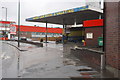
Car wash on Lower Parliament Street
There is an OS benchmark Image on the brick wall of #243 Lower Parliament on the brick wall on the right hand side of the image, just right of the small grey electric caninet
Image: © Roger Templeman
Taken: 9 Apr 2012
0.04 miles
8
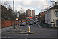
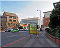
The Gates of Nottingham (5)
Fishergate
Nottingham has nearly 20 streets incorporating the Norse-derived 'Gate', meaning a thoroughfare, not a barrier.
Next in series Image
Image: © Alan Murray-Rust
Taken: 11 Feb 2007
0.04 miles
9
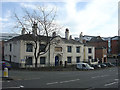
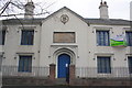
Plumptre Hospital
This was a foundation for a 'Master and 13 poor widows' dating back to 1392, the present building dating from 1823. The patronage had remained with the Plumptre family for the whole of this time, as related on the stone above the doorway.
The charity remained in the premises until 1991, after which it stood vacant for 10 years. Since then it has been the RNIB Employment and Education Centre, so it is still providing assistance to disadvantaged people.
A close-up of the plaque can be seen here Image
Image: © Alan Murray-Rust
Taken: 27 Jan 2008
0.04 miles
10
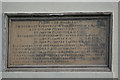
Plumptre Hospital commemorative panel
This is the stone panel which can be seen above the doorway in Image
Image: © Alan Murray-Rust
Taken: 27 Jan 2008
0.04 miles