IMAGES TAKEN NEAR TO
Hawksley Gardens, NOTTINGHAM, NG11 8SU
Introduction
This page details the photographs taken nearby to Hawksley Gardens, NG11 8SU by members of the Geograph project.
The Geograph project started in 2005 with the aim of publishing, organising and preserving representative images for every square kilometre of Great Britain, Ireland and the Isle of Man.

There are currently over 7.5m images from over14,400 individuals and you can help contribute to the project by visiting https://www.geograph.org.uk
Image Map
Images are licensed for reuse under creativecommons.org/licenses/by-sa/2.0
Notes
- Clicking on the map will re-center to the selected point.
- The higher the marker number, the further away the image location is from the centre of the postcode.
Image Listing (58 Images Found)
Images are licensed for reuse under creativecommons.org/licenses/by-sa/2.0
Image
Details
Distance
1
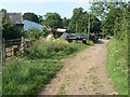
Bridleway at Clifton
Passing Home Farm.
Image: © Alan Murray-Rust
Taken: 29 May 2009
0.09 miles
2
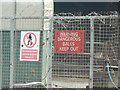
Do they bite or sting?
Sign at Home Farm, Clifton. The protective measures are however necessary due to the close proximity of the large Clifton Estate which has a history of vandalism.
Image: © Alan Murray-Rust
Taken: 29 May 2009
0.11 miles
3
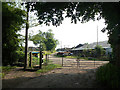
Track past Home Farm
This is a public bridleway as indicated by the horse-stile. However, the gate is clearly marked on the 1:50000 map.
Image: © Alan Murray-Rust
Taken: 29 May 2009
0.11 miles
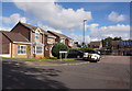
5

Housing on Hartness Road
Two contrasting styles of housing on Hartness Road, immediately to the north of the bus turning circle (see Image). This small estate, sometimes referred to as Barton Green, is effectively a later adjunct to the huge Clifton estate, from which it is separated by the A453.
Image: © Richard Vince
Taken: 23 Apr 2012
0.15 miles
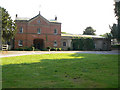
6
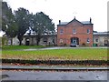
Former stable block of Clifton Hall
On Holgate in Clifton Village
Image: © Graham Hogg
Taken: 25 Nov 2019
0.16 miles
8
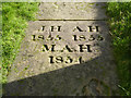
Gravestone in St Mary's churchyard
An unusually deeply carved slab, now in use to form a pathway. There is nothing to indicate who the individuals were. The closeness of the dates suggests perhaps infant mortality.
Image: © Alan Murray-Rust
Taken: 13 Feb 2014
0.16 miles
9
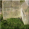
Bench mark, St Mary's Church, Clifton
See http://www.geograph.org.uk/photo/3851861 for location.
Image: © Alan Murray-Rust
Taken: 13 Feb 2014
0.16 miles
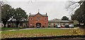
10
Stable block, Clifton Hall
Now converted to residential use.
Image: © Alan Murray-Rust
Taken: 29 May 2009
0.16 miles