IMAGES TAKEN NEAR TO
Dovenby Road, NOTTINGHAM, NG11 8AN
Introduction
This page details the photographs taken nearby to Dovenby Road, NG11 8AN by members of the Geograph project.
The Geograph project started in 2005 with the aim of publishing, organising and preserving representative images for every square kilometre of Great Britain, Ireland and the Isle of Man.

There are currently over 7.5m images from over14,400 individuals and you can help contribute to the project by visiting https://www.geograph.org.uk
Image Map
Images are licensed for reuse under creativecommons.org/licenses/by-sa/2.0
Notes
- Clicking on the map will re-center to the selected point.
- The higher the marker number, the further away the image location is from the centre of the postcode.
Image Listing (161 Images Found)
Images are licensed for reuse under creativecommons.org/licenses/by-sa/2.0
Image
Details
Distance
1
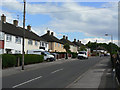
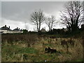
Dovenby Road
A typical road in the large Clifton Estate to the south of Nottingham. When built, in the 1950s, the estate was the largest single council estate in Europe.
Image: © Alan Murray-Rust
Taken: 21 May 2009
0.02 miles
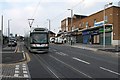
3
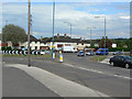
Southchurch Drive/Farnborough Road junction
This is the northern junction - the two thoroughfares meet again at the southern end of the estate. The proposed tram route will come down Southchurch Drive (from behind the photographer) and sweep right into Farnborough Road. The roundabout will disappear to be replaced with a signal-controlled junction.
Image: © Alan Murray-Rust
Taken: 21 May 2009
0.04 miles
4
Southchurch Drive/Farnborough Road junction
This is the northern junction - the two thoroughfares meet again at the southern end of the estate. The proposed tram route will come down Southchurch Drive (to the right) and sweep right into Farnborough Road (ahead). The roundabout will disappear to be replaced with a signal-controlled junction. The tram route will swing left again where the orange coloured house is.
Image: © Alan Murray-Rust
Taken: 21 May 2009
0.04 miles
5
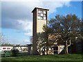
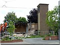
The site of the former church of St. Francis, Clifton
The church was built by voluntary labour between 1953 and 1957. It closed in 2009 and was demolished in 2019 https://southwellchurches.nottingham.ac.uk/clifton-st-francis/hhistory.php
Image: © Jonathan Thacker
Taken: 15 Feb 2022
0.05 miles
6
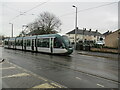
Tram departing Southchurch Drive North tramstop
Image: © Jonathan Thacker
Taken: 15 Feb 2022
0.05 miles
7
Demolition of St Francis Church, Clifton
The church was built during the early 1950s for the then new Clifton estate, largely using volunteer labour to reduce costs. By the 1990s, the fabric of the church was showing signs of deterioration, and with a dwindling congregation no funds were available for repairs. By 2009 the church was closed for worship, although the church hall continued to be used for services. The evangelical Hope Church, which had leased part of the church hall from 2001, moved into its own premises opposite in 2016, and in the same year St Francis merged with Holy Trinity at the southern end of the estate.
See http://southwellchurches.history.nottingham.ac.uk/clifton-st-francis/hintro.php for fuller information, and https://www.geograph.org.uk/photo/1069666 for a view of the church when still in use.
Image: © Alan Murray-Rust
Taken: 3 Jun 2019
0.05 miles
8
Southchurch Drive, north end
Road surfacing is complete at this location but ancillary work is behind schedule; the road should have been open to traffic a couple of weeks earlier.
Image: © Alan Murray-Rust
Taken: 13 Feb 2014
0.05 miles
9
Tram leaving the Southchurch Drive stop
A tram bound for Clifton South on a September morning - during the first month of services on the two new routes.
Image: © John Sutton
Taken: 10 Sep 2015
0.05 miles
10
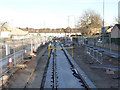
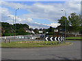
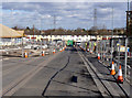
Southchurch Drive (northern section)
Progress with tracklaying. The rails are not yet finally aligned.
Image: © Alan Murray-Rust
Taken: 1 Dec 2013
0.05 miles