IMAGES TAKEN NEAR TO
Brookthorpe Way, NOTTINGHAM, NG11 7FE
Introduction
This page details the photographs taken nearby to Brookthorpe Way, NG11 7FE by members of the Geograph project.
The Geograph project started in 2005 with the aim of publishing, organising and preserving representative images for every square kilometre of Great Britain, Ireland and the Isle of Man.

There are currently over 7.5m images from over14,400 individuals and you can help contribute to the project by visiting https://www.geograph.org.uk
Image Map
Images are licensed for reuse under creativecommons.org/licenses/by-sa/2.0
Notes
- Clicking on the map will re-center to the selected point.
- The higher the marker number, the further away the image location is from the centre of the postcode.
Image Listing (9 Images Found)
Images are licensed for reuse under creativecommons.org/licenses/by-sa/2.0
Image
Details
Distance
1
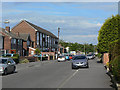
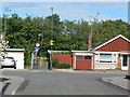
Monksway, Silverdale
The tall buildings are the estate's single parade of shops. Although designed as ten units, the furthest 4 now have residential accommodation on the ground floor. The local Post Office here closed a few years ago.
Image: © Alan Murray-Rust
Taken: 21 May 2009
0.11 miles
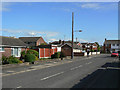
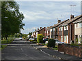
2
The Hollows, Silverdale
Typical residential road on this 1960s estate.
Image: © Alan Murray-Rust
Taken: 21 May 2009
0.14 miles
3
Spinney Way, Silverdale
Typical residential road on this 1960s estate.
Image: © Alan Murray-Rust
Taken: 21 May 2009
0.18 miles
5
Footpath off Stanthorne Close
Silverdale Estate is relatively isolated as far as vehicular traffic is concerned due to the presence of the Ring Road to the east. There are however a number of pedestrian links by subway through to Ruddington Lane, of which this is one. The lowest of the three notices requires people not to ride horses in the subway.
Image: © Alan Murray-Rust
Taken: 21 May 2009
0.20 miles
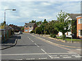
6
The Downs, Silverdale
Looking north towards Brookthorpe Way.
Image: © Alan Murray-Rust
Taken: 21 May 2009
0.21 miles
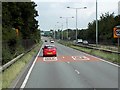
8
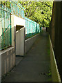
Subway under the Ring Road
Providing a pedestrian link from Silverdale estate to Ruddington Lane. At the time I used it was pleasantly free from both graffiti and smells.
Image: © Alan Murray-Rust
Taken: 21 May 2009
0.22 miles
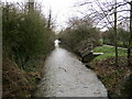
9
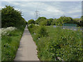
Footpath past Silverdale
This footpath runs alongside the Fairham Brook towards Clifton Bridge.
Image: © Alan Murray-Rust
Taken: 21 May 2009
0.22 miles