IMAGES TAKEN NEAR TO
Barnfield, NOTTINGHAM, NG11 7DT
Introduction
This page details the photographs taken nearby to Barnfield, NG11 7DT by members of the Geograph project.
The Geograph project started in 2005 with the aim of publishing, organising and preserving representative images for every square kilometre of Great Britain, Ireland and the Isle of Man.

There are currently over 7.5m images from over14,400 individuals and you can help contribute to the project by visiting https://www.geograph.org.uk
Image Map
Images are licensed for reuse under creativecommons.org/licenses/by-sa/2.0
Notes
- Clicking on the map will re-center to the selected point.
- The higher the marker number, the further away the image location is from the centre of the postcode.
Image Listing (77 Images Found)
Images are licensed for reuse under creativecommons.org/licenses/by-sa/2.0
Image
Details
Distance
1
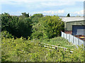
Former railway line
This is to be the alignment of the extension of the Nottingham tram route to Clifton. The original railway bridge has been replaced by infill, but the tram will cross the road by a level crossing here. The roadway will be lowered and the tramway raised above the old track bed. This will be the site of a tram stop.
Image: © Alan Murray-Rust
Taken: 21 May 2009
0.02 miles
2
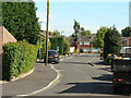
Barnfield
Residential road off Ruddington Lane
Image: © Alan Murray-Rust
Taken: 21 May 2009
0.02 miles
3
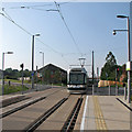
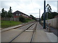
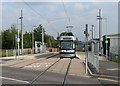
A northbound tram crossing Ruddington Lane
A tram from Clifton to the city and Phoenix Park crosses the road and slows for the Ruddington Lane stop.
Image: © John Sutton
Taken: 10 Sep 2015
0.04 miles
4
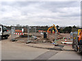
Ruddington Lane tramway crossing
Much of the roadway has now been dug away.
Image: © Alan Murray-Rust
Taken: 21 Feb 2013
0.04 miles
5
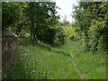
Footpath along the railway track
Looking towards Ruddington Lane on the embankment at the end. The proposed tram route to Clifton will come along here and will be slightly raised to make a level crossing with the road which will be lowered by some 2.4 metres. This will be the site for a tram stop.
Image: © Alan Murray-Rust
Taken: 29 May 2009
0.05 miles
7
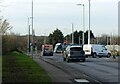
Bus meets tram, Ruddington Lane
The no.3 bus runs hourly between Nottingham and Clifton, via an indirect route that includes the village of Ruddington. In comparison, the tram provides a more direct service to Clifton, running every few minutes.
Image: © Alan Murray-Rust
Taken: 8 Feb 2023
0.05 miles
8
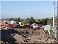
Ruddington Lane closed (2)
The tramway will cross the road on a new level crossing lower than the current road level so the road has to be completely rebuilt.
Image: © Alan Murray-Rust
Taken: 23 Nov 2012
0.05 miles
9

Preliminary work at Ruddington Lane
Hardstanding has been laid across the footway for vehicle access to the site.
Image: © Alan Murray-Rust
Taken: 30 Jul 2012
0.05 miles
10
Clifton tram at Ruddington Lane
A tram bound for Clifton South at one of the stops on the long section of reserved track between Wilford and Southchurch Drive, much of which follows the alignment of the former Great Central Railway line which closed in 1969. Ruddington Lane crossed the railway on a bridge. The site of the former Wilford Brickworks is to the right.
Image: © John Sutton
Taken: 10 Sep 2015
0.05 miles