IMAGES TAKEN NEAR TO
Brierfield Avenue, NOTTINGHAM, NG11 7DA
Introduction
This page details the photographs taken nearby to Brierfield Avenue, NG11 7DA by members of the Geograph project.
The Geograph project started in 2005 with the aim of publishing, organising and preserving representative images for every square kilometre of Great Britain, Ireland and the Isle of Man.

There are currently over 7.5m images from over14,400 individuals and you can help contribute to the project by visiting https://www.geograph.org.uk
Image Map
Images are licensed for reuse under creativecommons.org/licenses/by-sa/2.0
Notes
- Clicking on the map will re-center to the selected point.
- The higher the marker number, the further away the image location is from the centre of the postcode.
Image Listing (86 Images Found)
Images are licensed for reuse under creativecommons.org/licenses/by-sa/2.0
Image
Details
Distance
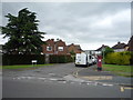
2
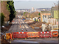
More track on the route to Clifton
Looking south from the crossing with Ruddington Lane. The track still needs to be finally aligned and fettled.
Image: © Alan Murray-Rust
Taken: 13 Jan 2014
0.04 miles
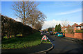
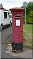
3
Brierfield Avenue
Showing position of Postbox No. NG11 137.
See Image] for postbox.
Image: © JThomas
Taken: 9 Jul 2016
0.05 miles
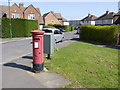
4
Elizabeth II postbox on Brierfield Avenue
Postbox No. NG11 137.
See Image] for context.
Image: © JThomas
Taken: 9 Jul 2016
0.05 miles
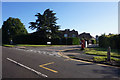
5
Briarfield Avenue postbox (ref. NG11 137)
A very ordinary E II R (Post Office) pillar box, resplendent in Post Office Pink. The drop box is mounted separately rather than being attached to the box. The road name-sign spells the road as Brierfield Avenue.
Image: © Alan Murray-Rust
Taken: 1 Apr 2012
0.05 miles
6
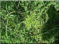
Cut-leaved cranesbill (Geranium dissectum)
On the footpath along the old railway alignment.
Image: © Alan Murray-Rust
Taken: 29 May 2009
0.06 miles
7
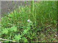
Dovesfoot Cranesbill (Geranium molle)
On the footpath along the old railway alignment.
Image: © Alan Murray-Rust
Taken: 29 May 2009
0.07 miles
8
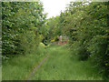
Footpath along the railway track
This will become part of the proposed tram route to Clifton. The brick construction is where industrial units have encroached on the track bed, and will have to be removed. This is roughly the location of the Ruddington Lane tram stop.
Image: © Alan Murray-Rust
Taken: 29 May 2009
0.07 miles