IMAGES TAKEN NEAR TO
Kingcup Gardens, NG11 6SD
Introduction
This page details the photographs taken nearby to Kingcup Gardens, NG11 6SD by members of the Geograph project.
The Geograph project started in 2005 with the aim of publishing, organising and preserving representative images for every square kilometre of Great Britain, Ireland and the Isle of Man.

There are currently over 7.5m images from over14,400 individuals and you can help contribute to the project by visiting https://www.geograph.org.uk
Image Map
Images are licensed for reuse under creativecommons.org/licenses/by-sa/2.0
Notes
- Clicking on the map will re-center to the selected point.
- The higher the marker number, the further away the image location is from the centre of the postcode.
Image Listing (2 Images Found)
Images are licensed for reuse under creativecommons.org/licenses/by-sa/2.0
Image
Details
Distance
1
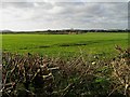
View towards Ruddington from Mill Lane
A public bridleway just enters the bottom SE corner of the square, giving a view over agricultural land
Image: © Ralph Mills
Taken: 11 Jan 2006
0.19 miles
2

The A60 south of Ruddington
Also just north of Bradmore.
Image: © David Lally
Taken: 18 Apr 2014
0.21 miles