IMAGES TAKEN NEAR TO
Moor Lane, NOTTINGHAM, NG11 6RJ
Introduction
This page details the photographs taken nearby to Moor Lane, NG11 6RJ by members of the Geograph project.
The Geograph project started in 2005 with the aim of publishing, organising and preserving representative images for every square kilometre of Great Britain, Ireland and the Isle of Man.

There are currently over 7.5m images from over14,400 individuals and you can help contribute to the project by visiting https://www.geograph.org.uk
Image Map
Images are licensed for reuse under creativecommons.org/licenses/by-sa/2.0
Notes
- Clicking on the map will re-center to the selected point.
- The higher the marker number, the further away the image location is from the centre of the postcode.
Image Listing (39 Images Found)
Images are licensed for reuse under creativecommons.org/licenses/by-sa/2.0
Image
Details
Distance
1
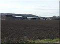
Farm on Bunny Moor
This is clearly the hub of farming activity on the Moor, and was sufficiently new when this picture was taken that was not named on any maps. The extent of storage gives an indication of the rich yields from the area, as does the dark colour of the soil.
Image: © Alan Murray-Rust
Taken: 23 Mar 2010
0.01 miles
2
Farm on Bunny Moor
This is clearly the hub of farming activity on the Moor, and was sufficiently new when this picture was taken that was not named on any maps.
Image: © Alan Murray-Rust
Taken: 23 Mar 2010
0.01 miles
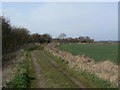
4
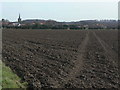
Field Footpath
Marked by the simple expedient of driving a tractor across the seeded soil. Old maps show that this footpath has been realigned at some stage, as it used to run on a slightly more westerly course to join the track at SK57122979.
Image: © Alan Murray-Rust
Taken: 23 Mar 2010
0.07 miles


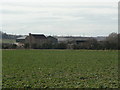
8
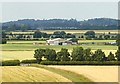
Farm near Bunny
Looking N from the footpath up to Bunny New Wood.
Image: © Chris J Dixon
Taken: 8 Jul 2005
0.13 miles
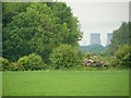
9
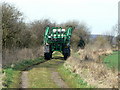
Moor Lane, Bunny
Making out onto the Moor with a sprayer.
Image: © Alan Murray-Rust
Taken: 23 Mar 2010
0.15 miles
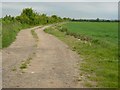
10
Moor Lane, Bunny
This is Bunny's Moor Lane, leading out onto its Moor. Classified as bridleway, it only has right of way access at either end via footpaths. It is of course also used by the local farmer http://www.geograph.org.uk/photo/1771530 .
Image: © Alan Murray-Rust
Taken: 23 Mar 2010
0.15 miles