IMAGES TAKEN NEAR TO
Littlemoor Lane, NOTTINGHAM, NG11 6PS
Introduction
This page details the photographs taken nearby to Littlemoor Lane, NG11 6PS by members of the Geograph project.
The Geograph project started in 2005 with the aim of publishing, organising and preserving representative images for every square kilometre of Great Britain, Ireland and the Isle of Man.

There are currently over 7.5m images from over14,400 individuals and you can help contribute to the project by visiting https://www.geograph.org.uk
Image Map
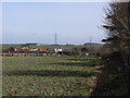
Images are licensed for reuse under creativecommons.org/licenses/by-sa/2.0
Notes
- Clicking on the map will re-center to the selected point.
- The higher the marker number, the further away the image location is from the centre of the postcode.
Image Listing (79 Images Found)
Images are licensed for reuse under creativecommons.org/licenses/by-sa/2.0
Image
Details
Distance
2
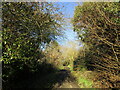
Main Street, Bradmore
This tiny village is on the west side of the A60, the main road from Nottingham to Loughborough. The majority of the houses are restored cottages and old shops and small workshops making it a highly interesting village. See Image] for more information.
Image: © Kate Jewell
Taken: 24 Jan 2008
0.06 miles
3
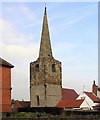
Bradmore Church
Completely hemmed-in by houses, it is impossible to photograph anything other than the C13th tower and C14th spire of this little church (here seen from the south-west). The church has had a couple of adventures..the Black Death struck whilst it was being built, and construction was halted. It was destroyed along with much of the village in a 1705 fire and lay derelict for a lengthy period (which is when the houses no doubt crept close).
Image: © Ralph Mills
Taken: 25 Jan 2006
0.07 miles
4
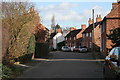
Far Street, Bradmore
Far Street runs parallel to Main Street and originally consisted mainly of labourers' cottages. The village pump is also on this street.
Image: © Kate Jewell
Taken: 24 Jan 2008
0.08 miles
5
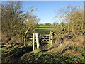
Gate into a grass field
The footpath sign indicates a path which is rather odd in that it parallels the bridleway from which this photograph was taken, separated from it only by a hedge.
Image: © Jonathan Thacker
Taken: 20 Jan 2023
0.10 miles
6
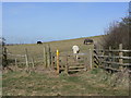
Stile on footpath from Little Moor Lane
Moor Lane itself, a perfectly good bridleway, runs parallel to the footpath at a distance of never more than 10 metres, so it is strange that they have remained as two separate rights of way. Even on the 1:25000 map it is difficult to spot this, and I thought I was following the bridleway until I reached the point where they join - just some 3-4 metres to the right here!
Image: © Alan Murray-Rust
Taken: 23 Mar 2010
0.10 miles
7
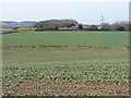
View towards Long Manor
From the western edge of Bradmore village.
Image: © Alan Murray-Rust
Taken: 23 Mar 2010
0.10 miles
8
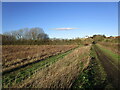
Bridleway and footpath to Bradmore
The bridleway is on the right. The footpath is the green strip along the field edge.
Image: © Jonathan Thacker
Taken: 20 Jan 2023
0.11 miles
9
Not the site of the windmill
The 1:25000 map indicates that the old Mill Mound was located at the high spot in this field. However, subsequent research shows that it is in the private garden behind the fence to the right.
Image: © Alan Murray-Rust
Taken: 23 Mar 2010
0.11 miles
10

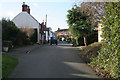
Houses on Main Street, Bradmore
What appear to be particularly bland council houses, in the centre of the village.
Image: © Richard Vince
Taken: 6 Jun 2015
0.12 miles