IMAGES TAKEN NEAR TO
Asher Lane, NOTTINGHAM, NG11 6JX
Introduction
This page details the photographs taken nearby to Asher Lane, NG11 6JX by members of the Geograph project.
The Geograph project started in 2005 with the aim of publishing, organising and preserving representative images for every square kilometre of Great Britain, Ireland and the Isle of Man.

There are currently over 7.5m images from over14,400 individuals and you can help contribute to the project by visiting https://www.geograph.org.uk
Image Map
Images are licensed for reuse under creativecommons.org/licenses/by-sa/2.0
Notes
- Clicking on the map will re-center to the selected point.
- The higher the marker number, the further away the image location is from the centre of the postcode.
Image Listing (18 Images Found)
Images are licensed for reuse under creativecommons.org/licenses/by-sa/2.0
Image
Details
Distance
1
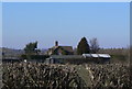
Moorend Farm Cottages
Seen from the lane to Moor Farm.
Image: © Alan Murray-Rust
Taken: 7 Mar 2010
0.01 miles
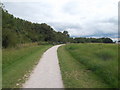
4
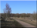
Footpath in Ruddington Country Park
Leading towards Fowemer Hill.
Image: © Alan Murray-Rust
Taken: 18 Mar 2022
0.08 miles
5
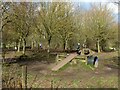
Dog Activity Trail
Installed around 2016, and clearly popular, although there are more people than dogs visible in this view.
Image: © Alan Murray-Rust
Taken: 18 Mar 2022
0.10 miles
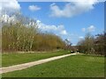
6
Path in the park
Rushcliffe Country Park was developed on the site of an old Ordnance Depot.
Image: © Alan Murray-Rust
Taken: 7 Mar 2010
0.11 miles
7
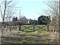
Moorend Farm
Not to be confused with Moor Farm.
Image: © Alan Murray-Rust
Taken: 7 Mar 2010
0.11 miles
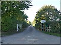
8
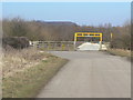
Entrance to Rushcliffe Country Park
This is a pedestrian and service access, the latter being currently used to bring in material for the resurfacing of paths.
Image: © Alan Murray-Rust
Taken: 7 Mar 2010
0.11 miles
9
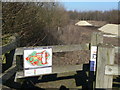
Dog Zones
The map indicates areas in red where dogs are not allowed (primarily woodland area and the lake), green where they allowed to run free, and amber where they must be under control on a lead. In practice, the red areas are surrounded by low fences, so the boundaries are conspicuous.
Image: © Alan Murray-Rust
Taken: 7 Mar 2010
0.11 miles
10
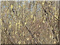
Hazel catkins
Always one of the early indicators that spring is on its way.
Image: © Alan Murray-Rust
Taken: 7 Mar 2010
0.11 miles