IMAGES TAKEN NEAR TO
Western Fields, NOTTINGHAM, NG11 6JE
Introduction
This page details the photographs taken nearby to Western Fields, NG11 6JE by members of the Geograph project.
The Geograph project started in 2005 with the aim of publishing, organising and preserving representative images for every square kilometre of Great Britain, Ireland and the Isle of Man.

There are currently over 7.5m images from over14,400 individuals and you can help contribute to the project by visiting https://www.geograph.org.uk
Image Map
Images are licensed for reuse under creativecommons.org/licenses/by-sa/2.0
Notes
- Clicking on the map will re-center to the selected point.
- The higher the marker number, the further away the image location is from the centre of the postcode.
Image Listing (37 Images Found)
Images are licensed for reuse under creativecommons.org/licenses/by-sa/2.0
Image
Details
Distance
1
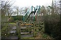
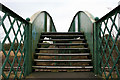
Footbridge over the Great Central Railway
The path between Vicarage Lane in Ruddington village and Pasture Lane off Clifton Road passes through the northern tip of Rushcliffe Country Park. This cycle barrier welcome you. The footbridge spans a restored section of the old Great Central Line in use by Nottingham Transport Heritage Centre http://www.nthc.co.uk/ .
Image: © David Lally
Taken: 24 Feb 2010
0.08 miles
2
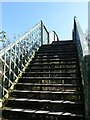
Ruddington: Fifty Steps Bridge
The bridge carries a footpath over what was once the Great Central Railway main line from Marylebone to Nottingham, Sheffield and Manchester, the first British main line to close. This section of the line is now part of the Great Central Railway (Nottingham), a heritage railway based at the former Ruddington Ordnance and Supply Depot.
Image: © John Sutton
Taken: 10 Sep 2014
0.09 miles
3
Ruddington - Public Open Space
Found in rear of Westerham Road and adjacent to Vicarage Lane cemetery.
Image: © Peter Whatley
Taken: 22 Mar 2009
0.09 miles
4
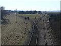
Looking south along the Great Central Railway
From a footbridge to the west of Ruddington http://www.geograph.org.uk/photo/1723879 . The branch off to the left now leads to the Nottingham Transport Heritage Centre http://www.nthc.co.uk/. In the days when the railway ran through here to London Marylebone Station this was the connection into the Ruddington MoD Ordnance and Supplies Depot set up in WW2.
Image: © David Lally
Taken: 24 Feb 2010
0.10 miles
5
Footbridge over the Great Central Railway
Just west of Ruddington. Many footbridges over running railways are not as well preserved as this one.
Image: © David Lally
Taken: 24 Feb 2010
0.10 miles
6
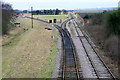
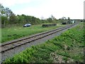
View from the footbridge
These are the tracks of the Great Central Railway (Nottingham), attached to the Nottingham Transport Heritage Centre. Access to the main line from the Heritage Centre still involves the reversal of trains at this junction. It was formerly the access to the Ruddington Ordnance Depot.
Image: © Alan Murray-Rust
Taken: 7 Mar 2010
0.10 miles
7
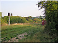
The line to Ruddington Fields
A branch off the Great Central main line, once serving a military base.
Image: © Christine Johnstone
Taken: 15 Apr 2017
0.10 miles
8
Footbridge over the railway
Originally a rural footpath, this is now a link between modern housing and industrial developments and the centre of the village. Known locally as '50 steps bridge'.
Image: © Alan Murray-Rust
Taken: 18 Mar 2022
0.10 miles
9
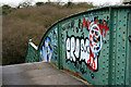
Footbridge Graffiti
Just inside Rushcliffe Country Park. The bridge spans the line of the Great Central Railway.
Image: © David Lally
Taken: 24 Feb 2010
0.10 miles
10
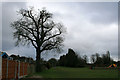
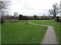
Oak tree and recreation ground
Looking toward the end of Vicarage Lane, Ruddington. The recreation ground is basically a patch of grass with a small children's play area, seen here on the right.
Image: © David Lally
Taken: 24 Feb 2010
0.10 miles