IMAGES TAKEN NEAR TO
Musters Road, NOTTINGHAM, NG11 6HZ
Introduction
This page details the photographs taken nearby to Musters Road, NG11 6HZ by members of the Geograph project.
The Geograph project started in 2005 with the aim of publishing, organising and preserving representative images for every square kilometre of Great Britain, Ireland and the Isle of Man.

There are currently over 7.5m images from over14,400 individuals and you can help contribute to the project by visiting https://www.geograph.org.uk
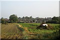
Image Map
Images are licensed for reuse under creativecommons.org/licenses/by-sa/2.0
Notes
- Clicking on the map will re-center to the selected point.
- The higher the marker number, the further away the image location is from the centre of the postcode.
Image Listing (75 Images Found)
Images are licensed for reuse under creativecommons.org/licenses/by-sa/2.0
Image
Details
Distance
1
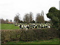
Ruddington - Vicarage Lane Cemetery
Somewhat inappropriately a children's playground has been placed alongside the cemetery, from which vantage point the photo was taken.
Image: © Peter Whatley
Taken: 22 Mar 2009
0.06 miles
2
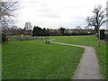
Ruddington - Public Open Space
Found in rear of Westerham Road and adjacent to Vicarage Lane cemetery.
Image: © Peter Whatley
Taken: 22 Mar 2009
0.09 miles
3
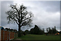
Oak tree and recreation ground
Looking toward the end of Vicarage Lane, Ruddington. The recreation ground is basically a patch of grass with a small children's play area, seen here on the right.
Image: © David Lally
Taken: 24 Feb 2010
0.10 miles
4

Ruddington: Distillery Street
Some fairly typical South Notts village houses.
Image: © John Sutton
Taken: 24 Jun 2014
0.14 miles
5
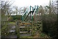
Footbridge over the Great Central Railway
The path between Vicarage Lane in Ruddington village and Pasture Lane off Clifton Road passes through the northern tip of Rushcliffe Country Park. This cycle barrier welcome you. The footbridge spans a restored section of the old Great Central Line in use by Nottingham Transport Heritage Centre http://www.nthc.co.uk/ .
Image: © David Lally
Taken: 24 Feb 2010
0.16 miles
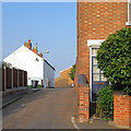
6
The edge of Ruddington
The backs of houses on Musters Road, seen across the fields from Asher Lane.
Image: © John Sutton
Taken: 10 Sep 2014
0.17 miles
7
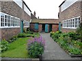
Framework Knitters Museum - coal store, privies etc
At the southern end of the yard, beyond the workshops. This is the only surviving example of a purpose-built knitters yard, once common in this part of the East Midlands. It was built in 1829. The Framework Knitters Museum covers both industrial and social history and is well worth visiting. Open February to December Wednesdays to Saturdays, plus Sundays from April to September.
Image: © Christine Johnstone
Taken: 15 Apr 2017
0.17 miles
8
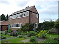
Framework Knitters Museum - the western workshops
Where stockingers knitted cloth by pedal power. This is the only surviving example of a purpose-built knitters yard, once common in this part of the East Midlands. It was built in 1829, although the workshops are slightly later. The Framework Knitters Museum covers both industrial and social history and is well worth visiting. Open February to December Wednesdays to Saturdays, plus Sundays from April to September.
Image: © Christine Johnstone
Taken: 15 Apr 2017
0.17 miles
9
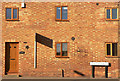
Waggoners Cottage
Modernised traditional building, converted to housing.
Image: © Alan Murray-Rust
Taken: 7 Mar 2010
0.17 miles
10
Ruddington: Top Road
Bright sunlight on a September morning. The house in the foreground is on Asher Lane.
Image: © John Sutton
Taken: 10 Sep 2014
0.17 miles