IMAGES TAKEN NEAR TO
Dickson Drive, NOTTINGHAM, NG11 6GT
Introduction
This page details the photographs taken nearby to Dickson Drive, NG11 6GT by members of the Geograph project.
The Geograph project started in 2005 with the aim of publishing, organising and preserving representative images for every square kilometre of Great Britain, Ireland and the Isle of Man.

There are currently over 7.5m images from over14,400 individuals and you can help contribute to the project by visiting https://www.geograph.org.uk
Image Map
Images are licensed for reuse under creativecommons.org/licenses/by-sa/2.0
Notes
- Clicking on the map will re-center to the selected point.
- The higher the marker number, the further away the image location is from the centre of the postcode.
Image Listing (16 Images Found)
Images are licensed for reuse under creativecommons.org/licenses/by-sa/2.0
Image
Details
Distance
1
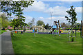
Playground in Elms Park
I was surprised to see this deserted on a warm and sunny Good Friday.
Image: © David Lally
Taken: 18 Apr 2014
0.07 miles
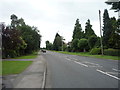
2
Moor Lane
Despite the name, this does not follow the line of a lane giving access onto Ruddington Moor.
Image: © Alan Murray-Rust
Taken: 7 Mar 2010
0.14 miles
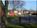
3
Dunblane Road
A typical street in the housing development to the south of the village centre.
Image: © Alan Murray-Rust
Taken: 7 Mar 2010
0.17 miles
4
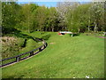
The eastern end of the miniature railway
In Rushcliffe Country Park. Operated by the Nottingham Society of Model and Experimental Engineers Ltd. The inner raised track is a narrower gauge than the outer track.
Image: © Christine Johnstone
Taken: 15 Apr 2017
0.18 miles
5
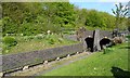
Western tunnel portals on the raised track
Part of the infrastructure of the miniature railway operated by the Nottingham Society of Model and Experimental Engineers Ltd at Rushcliffe Country Park.
Image: © Christine Johnstone
Taken: 15 Apr 2017
0.18 miles
6

Miniature railway in Rushcliffe Country Park
Image: © Stephen Sweeney
Taken: 3 Jul 2016
0.19 miles
7
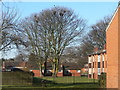
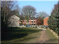
Urban rookery
This colony of rooks certainly seem to be untroubled by nesting in the middle of a housing estate.
Image: © Alan Murray-Rust
Taken: 7 Mar 2010
0.20 miles
8
Loughborough Road (A60), Ruddington
Looking south.
Image: © JThomas
Taken: 9 Jul 2016
0.20 miles
9
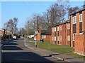
Leys Road
The housing on the right is an elderly persons' complex.
Image: © Alan Murray-Rust
Taken: 7 Mar 2010
0.21 miles
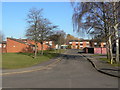
10
Exit from the park
The Country Park lies close to the newer residential areas of Ruddington.
Image: © Alan Murray-Rust
Taken: 7 Mar 2010
0.21 miles