IMAGES TAKEN NEAR TO
Clifton Road, NOTTINGHAM, NG11 6DE
Introduction
This page details the photographs taken nearby to Clifton Road, NG11 6DE by members of the Geograph project.
The Geograph project started in 2005 with the aim of publishing, organising and preserving representative images for every square kilometre of Great Britain, Ireland and the Isle of Man.

There are currently over 7.5m images from over14,400 individuals and you can help contribute to the project by visiting https://www.geograph.org.uk
Image Map
Images are licensed for reuse under creativecommons.org/licenses/by-sa/2.0
Notes
- Clicking on the map will re-center to the selected point.
- The higher the marker number, the further away the image location is from the centre of the postcode.
Image Listing (89 Images Found)
Images are licensed for reuse under creativecommons.org/licenses/by-sa/2.0
Image
Details
Distance
1
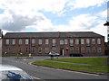
Victoria Court, Ruddington
This old textile mill has been converted into 12 townhouses.
Image: © Oxymoron
Taken: 12 Jul 2008
0.05 miles
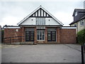
2
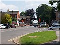
Ruddington
Although only a small village to the south of Nottingham, Ruddington has three museums, three churches and seven pubs. http://www.ruddington.com/home.htm
Image: © Garth Newton
Taken: 4 Jun 2006
0.05 miles
3
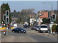
Wilford Road
This would have been the principal road to Nottingham when Wilford Bridge was still open to traffic, but the A60 Loughborough Road now provides the quickest link. This is the junction with Clifton Road.
Image: © Alan Murray-Rust
Taken: 7 Mar 2010
0.06 miles
4
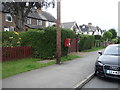
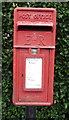
Elizabeth II postbox on Wilford Road, Ruddington
Postbox No. NG11 338.
See Image] for close up.
Image: © JThomas
Taken: 9 Jul 2016
0.06 miles
5
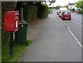
Close up, Elizabeth II postbox on Wilford Road, Ruddington
Postbox No. NG11 338.
See Image] for wider view.
Image: © JThomas
Taken: 9 Jul 2016
0.06 miles
7
Ruddington, Wilford Road postbox ref NG11 338
Standard freestanding EIIR lampbox alongside the old main road to Nottingham via Wilford.
Image: © Alan Murray-Rust
Taken: 27 Jun 2012
0.07 miles
8
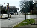
Ruddington
Recreating this 'First' for the square https://www.geograph.org.uk/photo/182048
The mini-roundabout layout was installed around 2017, and the prominent red gable on the left of Garth's view has been demolished.
Image: © Alan Murray-Rust
Taken: 18 Mar 2022
0.07 miles
10
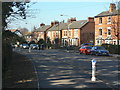
Clifton Road
With 2- and 3-storey late Victorian town houses.
Image: © Alan Murray-Rust
Taken: 7 Mar 2010
0.07 miles