IMAGES TAKEN NEAR TO
Brookside Road, NOTTINGHAM, NG11 6AT
Introduction
This page details the photographs taken nearby to Brookside Road, NG11 6AT by members of the Geograph project.
The Geograph project started in 2005 with the aim of publishing, organising and preserving representative images for every square kilometre of Great Britain, Ireland and the Isle of Man.

There are currently over 7.5m images from over14,400 individuals and you can help contribute to the project by visiting https://www.geograph.org.uk
Image Map
Images are licensed for reuse under creativecommons.org/licenses/by-sa/2.0
Notes
- Clicking on the map will re-center to the selected point.
- The higher the marker number, the further away the image location is from the centre of the postcode.
Image Listing (19 Images Found)
Images are licensed for reuse under creativecommons.org/licenses/by-sa/2.0
Image
Details
Distance
1
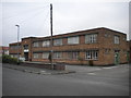
Malmic Lace Ltd factory, Ruddington (1)
The main frontage on Brookside Road.
Image: © Richard Vince
Taken: 23 Sep 2013
0.05 miles
2
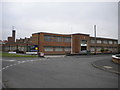
Malmic Lace Ltd factory, Ruddington (2)
Seen from Camelot Street where it meets Brookside Road (centre right). Despite the "For Sale" sign, the factory still seemed to be in use.
Image: © Richard Vince
Taken: 23 Sep 2013
0.06 miles
4
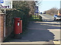
Clifton Road, Ruddington
Looking west showing position of Postbox No. NG11 301.
See Image] for postbox.
Image: © JThomas
Taken: 9 Jul 2016
0.16 miles
5
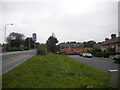
Two levels in Ruddington
Near the western edge of Ruddington, Clifton Road (left) and Camelot Street run parallel for a short distance, with the former rising to cross the former Great Central Railway line, which passed behind the houses in the distance.
Image: © Richard Vince
Taken: 23 Sep 2013
0.16 miles
6
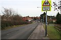
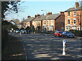
Clifton Road, Ruddington
Looking east toward the village. The road is rising here, not due to a natural hill, but up an embankment which takes the road over a now disused railway line
Image: © David Lally
Taken: 1 Feb 2010
0.16 miles
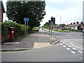
7
Clifton Road postbox, ref NG11 301
Standard G VI R pillar box on the corner of Churchill Drive.
Image: © Alan Murray-Rust
Taken: 7 Mar 2010
0.17 miles
8
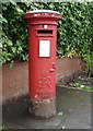
George VI postbox on Clifton Road, Ruddington
Postbox No. NG11 301.
See Image] for context.
Image: © JThomas
Taken: 9 Jul 2016
0.17 miles
9
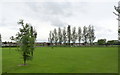
Wilford Road Recreation Ground
A small recreation ground on the northern edge of Ruddington, with football pitch.
Image: © Alan Murray-Rust
Taken: 27 Jun 2012
0.17 miles
10
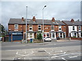
Clifton Road
With 2- and 3-storey late Victorian town houses.
Image: © Alan Murray-Rust
Taken: 7 Mar 2010
0.19 miles