IMAGES TAKEN NEAR TO
Longmoor Lane, NOTTINGHAM, NG10 5JH
Introduction
This page details the photographs taken nearby to Longmoor Lane, NG10 5JH by members of the Geograph project.
The Geograph project started in 2005 with the aim of publishing, organising and preserving representative images for every square kilometre of Great Britain, Ireland and the Isle of Man.

There are currently over 7.5m images from over14,400 individuals and you can help contribute to the project by visiting https://www.geograph.org.uk
Image Map
Images are licensed for reuse under creativecommons.org/licenses/by-sa/2.0
Notes
- Clicking on the map will re-center to the selected point.
- The higher the marker number, the further away the image location is from the centre of the postcode.
Image Listing (108 Images Found)
Images are licensed for reuse under creativecommons.org/licenses/by-sa/2.0
Image
Details
Distance
1
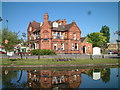
The Red Lion, Sandiacre, Nottingham.
Viewed from the Erewash Canal towpath, known as Padmore Moorings, on a beautiful May Sunday morning.
Image: © Patrick A Griffin
Taken: 15 May 2005
0.03 miles
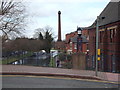
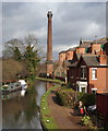
2
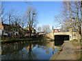
Station Road Bridge over the Erewash Canal, Sandiacre
Image: © Jonathan Thacker
Taken: 26 Jan 2022
0.04 miles
3
Erewash Canal
This bridge carries the B5010 over the canal
Image: © Tim Glover
Taken: 17 Jan 1999
0.04 miles
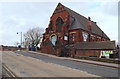
4
Former Sandiacre Methodist church
Designed by Arthur Marshall https://en.wikipedia.org/wiki/Arthur_George_Marshall 1886.
Image: © Jonathan Thacker
Taken: 26 Jan 2022
0.05 miles
5
Station Road, Sandiacre, Derbys.
This view from Station Road (the town centre stretch of Derby Road (B5010) includes a corner of Springfield Hall - a former Victorian Methodist Church; a house sandwiched between Bridge Street and the Erewash Canal towpath and in the distance is the former Springfield Mill. The mill was built in 1888 as a tenanted lace factory, for Terah Hooley a wealthy local industrialist, by the architect John Sheldon of Long Eaton.
Image: © David Hallam-Jones
Taken: 14 Feb 2013
0.05 miles
6
Town Street and Erewash Canal, Sandiacre
Looking north from Station Road along Town Street (left) and the Erewash Canal.
Image: © Richard Vince
Taken: 7 Jul 2012
0.05 miles
7
Station Road, Sandiacre, Derbys.
The Station Road stretch of Derby Road (the B5010) ascends here in order to cross the Erewash Canal. Opposite is a former United Methodist Free Church built in 1887. It was known as "The Chapel on the Bridge" but it closed in 1965 reopening in 2012 as "Springfield Hall", a functions suite.
Image: © David Hallam-Jones
Taken: 14 Feb 2013
0.05 miles
8
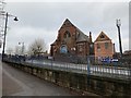
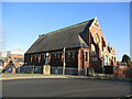
Stapleford former Central Methodist Church
Built in 1886 as a Methodist Church, Stapleford, this is now a Special Occasion & Events Hall.
Image: © Andrew Abbott
Taken: 28 Dec 2019
0.06 miles
9
Springfield Mills, Sandiacre, Derbys.
The houses on the right are sandwiched between Bridge Street and the Erewash Canal towpath and in the distance is the former Springfield Mill. The mill was built in 1888 as a tenanted lace factory, for Terah Hooley a wealthy local industrialist, by the architect John Sheldon of Long Eaton.
Image: © David Hallam-Jones
Taken: 14 Feb 2013
0.06 miles
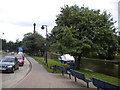
10
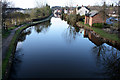
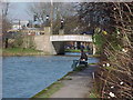
Erewash Canal in Sandiacre
The canal widens to a small basin as it passes under the bridge on Station Road.
This is looking South towards Long Eaton.
Image: © David Lally
Taken: 11 Apr 2008
0.06 miles