IMAGES TAKEN NEAR TO
Shaftesbury Avenue, NOTTINGHAM, NG10 5GU
Introduction
This page details the photographs taken nearby to Shaftesbury Avenue, NG10 5GU by members of the Geograph project.
The Geograph project started in 2005 with the aim of publishing, organising and preserving representative images for every square kilometre of Great Britain, Ireland and the Isle of Man.

There are currently over 7.5m images from over14,400 individuals and you can help contribute to the project by visiting https://www.geograph.org.uk
Image Map
Images are licensed for reuse under creativecommons.org/licenses/by-sa/2.0
Notes
- Clicking on the map will re-center to the selected point.
- The higher the marker number, the further away the image location is from the centre of the postcode.
Image Listing (15 Images Found)
Images are licensed for reuse under creativecommons.org/licenses/by-sa/2.0
Image
Details
Distance
1
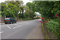
Derby Road, Sandiacre
Looking down the hill towards the centre of Sandiacre. This is now the B5010 but was once the A52, the principal route between Nottingham and Derby. For very many years Sandiacre has been by-passed by the modern A52 to the south.
Image: © Stephen McKay
Taken: 26 May 2014
0.07 miles
3
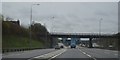
M1 near Sandiacre
The M1, looking north from Derby Road, as it passes Sandiacre (right).
Image: © Richard Vince
Taken: 7 Jul 2012
0.14 miles
4
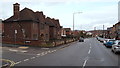
Bland's Almshouses, Sandiacre, Derbys
On this corner, where Stevens Road branches off Derby Road (the B5010), passers-by get this glimpse of Dr Bland's Almshouses, two semi-detached properties funded in the early 20th century by a local doctor.
Image: © David Hallam-Jones
Taken: 14 Feb 2013
0.16 miles
5
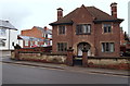
Bland's Almshouses, Sandiacre, Derbys.
"Dr Bland's Almshouses, 1910" on Derby Road (the B5010). This semi-detached house, and an identical one adjacent to it, was funded through a legacy left by a local doctor. Stevens Road can be seen at the side of it.
Image: © David Hallam-Jones
Taken: 14 Feb 2013
0.16 miles
6

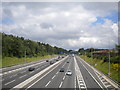
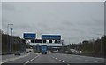
Erewash : M1 Motorway
The M1 Motorway between Junction 25 (Sandiacre) and Junction 26 (Nuthall).
Image: © Lewis Clarke
Taken: 30 Sep 2018
0.16 miles
7
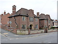
Dr Bland's Almshouses, Sandiacre
A pair of semidetached pairs, constructed in 1910 under the will of a local doctor. The design displays features of the Arts and Crafts movement. The two houses are separately Listed Grade II.
Image: © Alan Murray-Rust
Taken: 4 May 2014
0.16 miles
8
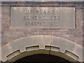
Inscription, Dr Bland's Almshouses, Sandiacre
See http://www.geograph.org.uk/photo/3979349 for the houses themselves, each of which has an identical inscription.
Image: © Alan Murray-Rust
Taken: 4 May 2014
0.16 miles
10
Old milepost, Derby Road, Sandiacre
Early 19th century cast-iron turnpike milepost, inscribed NOTTM 7 MILES and DERBY 9 MILES. Listed Grade II. See http://www.geograph.org.uk/photo/3948046 for location.
Image: © Alan Murray-Rust
Taken: 20 Apr 2014
0.19 miles