IMAGES TAKEN NEAR TO
Laburnum Close, NOTTINGHAM, NG10 5FA
Introduction
This page details the photographs taken nearby to Laburnum Close, NG10 5FA by members of the Geograph project.
The Geograph project started in 2005 with the aim of publishing, organising and preserving representative images for every square kilometre of Great Britain, Ireland and the Isle of Man.

There are currently over 7.5m images from over14,400 individuals and you can help contribute to the project by visiting https://www.geograph.org.uk
Image Map
Images are licensed for reuse under creativecommons.org/licenses/by-sa/2.0
Notes
- Clicking on the map will re-center to the selected point.
- The higher the marker number, the further away the image location is from the centre of the postcode.
Image Listing (17 Images Found)
Images are licensed for reuse under creativecommons.org/licenses/by-sa/2.0
Image
Details
Distance
1
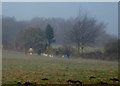
Cloudside, Sandiacre, Derbys.
These early morning dog-walkers have left the closed end of the Church Drive cul-de-sac behind and appear to be making their way across this public open space - known as Cloudside - towards Cloudside Drive. This grassy area sits atop a sandstone outcrop with views across Erewash Valley Golf Course, Stanton by Dale and the former Stanton Ironworks. The name "Stony Clud" is said to come from "clud", the Saxon word for hill.
Image: © David Hallam-Jones
Taken: 16 Feb 2013
0.10 miles

5
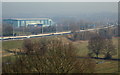
View from Cloudside, Sandiacre, Derbys.
A view from the north-west boundary of Cloudside, a public open space reached from either Church Drive or Cloudside Drive. This is a grassy area situated on the plateau of a sandstone outcrop providing views across a stretch of the M1 motorway, the Erewash Valley Golf Club site, Stanton by Dale and the former Stanton Ironworks. The name "Stony Clud" (Stony Cloud in its more modern form) is said to come from "clud", the Saxon word for hill.
Image: © David Hallam-Jones
Taken: 16 Feb 2013
0.20 miles
6
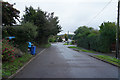
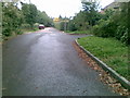
Stanton Road in Sandiacre
A road of detached and semi-detached houses on the edge of Sandiacre.
Image: © Malcolm Neal
Taken: 15 Oct 2019
0.20 miles
7
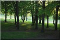
Evening trees
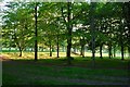
On Erewash Valley Golf Course.
Image: © David Lally
Taken: 2 May 2020
0.21 miles