IMAGES TAKEN NEAR TO
Osmaston Street, NOTTINGHAM, NG10 5AN
Introduction
This page details the photographs taken nearby to Osmaston Street, NG10 5AN by members of the Geograph project.
The Geograph project started in 2005 with the aim of publishing, organising and preserving representative images for every square kilometre of Great Britain, Ireland and the Isle of Man.

There are currently over 7.5m images from over14,400 individuals and you can help contribute to the project by visiting https://www.geograph.org.uk
Image Map
Images are licensed for reuse under creativecommons.org/licenses/by-sa/2.0
Notes
- Clicking on the map will re-center to the selected point.
- The higher the marker number, the further away the image location is from the centre of the postcode.
Image Listing (118 Images Found)
Images are licensed for reuse under creativecommons.org/licenses/by-sa/2.0
Image
Details
Distance
1
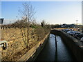
The River Erewash between Stapleford and Sandiacre
Looking downstream, Sandiacre to the right. The river forms the boundary between Nottinghamshire and Derbyshire.
Image: © Jonathan Thacker
Taken: 26 Jan 2022
0.08 miles
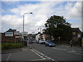
2
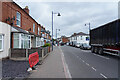
Station Road
There is a queue of traffic for the lights on the junction which is in the direction the vehicles are facing.
Image: © Malcolm Neal
Taken: 24 Jun 2021
0.08 miles
5

Station Road in Sandiacre
The B5010 Road pictured here at the junction with Mark Street.
Image: © Jonathan Clitheroe
Taken: 15 Aug 2013
0.10 miles
6
Welcome to Sandiacre
The sign welcoming people to Sandiacre marks the boundary between the towns of Stapleford and Sandiacre, the boroughs of Broxtowe and Erewash, and the counties of Nottinghamshire and Derbyshire. It is located next to the parapet of the small bridge that carries Station Road over the River Erewash; therefore it appears that the Derbyshire sign on the railway bridge (see Image) was jumping the gun rather.
Image: © Richard Vince
Taken: 7 Jul 2012
0.10 miles
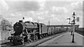
7
Up coal train at Stapleford & Sandiacre Station
View northward, towards Chesterfield; ex-Midland Erewash Valley main line Trent - Chesterfield. It was the constant output of coal from the many collieries in the North Midlands Area that together with other freight traffic on the North-South axis made the Erewash Valley line so extremely busy. The coal trains were assembled at the great Toton Marshalling Yard, then distributed south and west from there. This train is coming under the B5010 (formerly A52) bridge (before the new A52(T) was built) and is about to enter Toton Yard, which began immediately south of Stapleford & Sandiacre Station (closed 2/1/67). It is headed by ex-WD 2-8-0 No. 90612, which was built in 1/44 as No. 7468 (later 77468), loaned to the LNER (at Colwick) until 12/44 when it was shipped to France: it worked in Belgium and was repatriated in 6/46, stored at Northampton LMS, then in 1/47 was loaned to the LNER (at Annesley) and remained on BR (ER) (as No. 90612) until withdrawn in 8/64.
Image: © Ben Brooksbank
Taken: 17 May 1962
0.11 miles
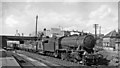
8
Down empties train at Stapleford & Sandiacre Station
View southward to Toton Yard, Trent and the South and West; ex-Midland Erewash Valley main line. (See Image for details). The locomotive is Stanier 8F 2-8-0 No. 48384. The coaling-plant tower at Toton Locomotive Depot can just be seen, beyond the footbridge where the A52(T) now crosses.
Image: © Ben Brooksbank
Taken: 17 May 1962
0.11 miles
9
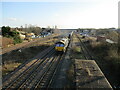
66126 and Tesco train
Passing the site of Stapleford and Sandiacre station.
Image: © Jonathan Thacker
Taken: 26 Jan 2022
0.11 miles
10
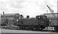
LMS Fowler 0-6-0T shunting at Stapleford & Sandiacre
View westward to goods yard of this station just north of Toton Yard. No. 47551 was built 1928 as No. 16634 and withdrawn 2/63.
Image: © Ben Brooksbank
Taken: 17 May 1962
0.11 miles