IMAGES TAKEN NEAR TO
Bennett Street, NOTTINGHAM, NG10 4RB
Introduction
This page details the photographs taken nearby to Bennett Street, NG10 4RB by members of the Geograph project.
The Geograph project started in 2005 with the aim of publishing, organising and preserving representative images for every square kilometre of Great Britain, Ireland and the Isle of Man.

There are currently over 7.5m images from over14,400 individuals and you can help contribute to the project by visiting https://www.geograph.org.uk
Image Map
Images are licensed for reuse under creativecommons.org/licenses/by-sa/2.0
Notes
- Clicking on the map will re-center to the selected point.
- The higher the marker number, the further away the image location is from the centre of the postcode.
Image Listing (231 Images Found)
Images are licensed for reuse under creativecommons.org/licenses/by-sa/2.0
Image
Details
Distance
1
Satellite dishes
On Bennett Street, Long Eaton.
Image: © David Lally
Taken: 13 Mar 2010
0.01 miles
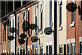
2
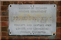
Private Parking
On the wall of a small car park at the rear of Image
Image: © David Lally
Taken: 2 Apr 2010
0.03 miles
3
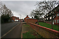
Bridge Street
Looking south(ish) from the north end of the street. On the right is the rear of Image
Image: © David Lally
Taken: 2 Apr 2010
0.03 miles
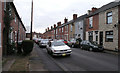
5
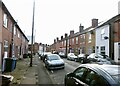
Bennett Street, Long Eaton
Recreating this 'First' for the square https://www.geograph.org.uk/photo/643626 .
Image: © Alan Murray-Rust
Taken: 1 Mar 2022
0.03 miles
6
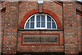
Goodwin Mills
Name stone on the small mill that spans between Bridge Street (where this was taken) and Bennett Street http://www.geograph.org.uk/photo/1602317 .
Image: © David Lally
Taken: 2 Apr 2010
0.04 miles
7
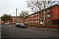
Erewash Court
On Bennett Street, Long Eaton.
Image: © David Lally
Taken: 2 Nov 2009
0.05 miles
8
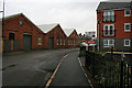
Bridge Street
Goodwin Mills on the left a block of basic apartments apparently called "Waters Edge" on the right. The latter will have been named such due to the fact that the other side is on the west bank of the Erewash Canal http://www.geograph.org.uk/photo/1679092 .
Image: © David Lally
Taken: 2 Apr 2010
0.05 miles
9
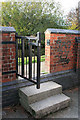
Gate to the towpath
At the end of Hemlock Avenue. It leads directly onto the towpath of the Erewash Canal. The view through the gate onto road can be seen here Image
Image: © David Lally
Taken: 2 Nov 2009
0.05 miles
10
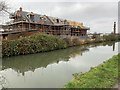
New build properties
On Bridge Street, Long Eaton.
Image: © Andrew Abbott
Taken: 28 Dec 2019
0.05 miles