IMAGES TAKEN NEAR TO
Dockholm Road, NOTTINGHAM, NG10 4JP
Introduction
This page details the photographs taken nearby to Dockholm Road, NG10 4JP by members of the Geograph project.
The Geograph project started in 2005 with the aim of publishing, organising and preserving representative images for every square kilometre of Great Britain, Ireland and the Isle of Man.

There are currently over 7.5m images from over14,400 individuals and you can help contribute to the project by visiting https://www.geograph.org.uk
Image Map
Images are licensed for reuse under creativecommons.org/licenses/by-sa/2.0
Notes
- Clicking on the map will re-center to the selected point.
- The higher the marker number, the further away the image location is from the centre of the postcode.
Image Listing (80 Images Found)
Images are licensed for reuse under creativecommons.org/licenses/by-sa/2.0
Image
Details
Distance
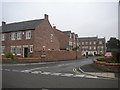
1
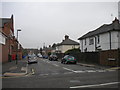
Dockholm Road, Long Eaton
A residential street linking College Street (foreground) with Wellington Street.
Image: © Richard Vince
Taken: 25 Sep 2013
0.04 miles
2
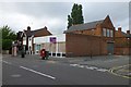
Empty Shop on College Street
On the corner of Dockholm Road. Last occupied by a Sainsbury's Local which closed last year,
Image: © David Lally
Taken: 7 Jul 2016
0.05 miles
3
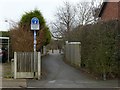
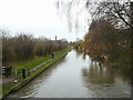
Pathway to Dockholme Lock
The Erewash Canal towpath forms part of Sustrans route 67, as indicated by the signs, as well as the Erewash Valley Way and the Nutbrook Trail long distance paths.
Image: © Alan Murray-Rust
Taken: 1 Jan 2018
0.11 miles
4
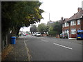
College Street, Long Eaton (2)
Looking north from near the junction with Spinney Road.
Image: © Richard Vince
Taken: 25 Sep 2013
0.11 miles
5
Erewash Canal, Long Eaton
Looking south from Bridge 7 at Dockholme Lock.
Image: © Alan Murray-Rust
Taken: 1 Jan 2018
0.12 miles
6
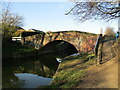
Bridge at Dockholme Lock, Erewash Canal
Dates from 1779. Listed https://historicengland.org.uk/listing/the-list/list-entry/1087968?section=official-listing
Image: © Jonathan Thacker
Taken: 26 Jan 2022
0.12 miles
7
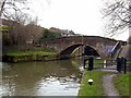
Dockholm Bridge , No.7, Erewash Canal
Both bridge and lock date from the construction of the canal in 1777-79, and both are Listed Grade II, the bridge however for its group value only.
Image: © Alan Murray-Rust
Taken: 1 Jan 2018
0.12 miles
8
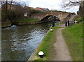
Dockholme Lock Footbridge No 7
Next to Dockholme Lock No 62 on the Erewash Canal.
Image: © Mat Fascione
Taken: 28 Feb 2016
0.12 miles
9
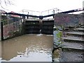
Bottom gates, Dockholme Lock, Erewash Canal
Image: © Christine Johnstone
Taken: 24 Jan 2010
0.12 miles
10
Bursar Way, Long Eaton
A relatively new residential cul de sac off College Street.
Image: © Richard Vince
Taken: 25 Sep 2013
0.12 miles