IMAGES TAKEN NEAR TO
Wellington Street, NOTTINGHAM, NG10 4JJ
Introduction
This page details the photographs taken nearby to Wellington Street, NG10 4JJ by members of the Geograph project.
The Geograph project started in 2005 with the aim of publishing, organising and preserving representative images for every square kilometre of Great Britain, Ireland and the Isle of Man.

There are currently over 7.5m images from over14,400 individuals and you can help contribute to the project by visiting https://www.geograph.org.uk
Image Map
Images are licensed for reuse under creativecommons.org/licenses/by-sa/2.0
Notes
- Clicking on the map will re-center to the selected point.
- The higher the marker number, the further away the image location is from the centre of the postcode.
Image Listing (74 Images Found)
Images are licensed for reuse under creativecommons.org/licenses/by-sa/2.0
Image
Details
Distance
1
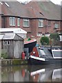
A garden full of boats, the Erewash Canal, Long Eaton
Perch is on land, hiding behind the shed, and Tasmania is in the water.
Image: © Christine Johnstone
Taken: 24 Jan 2010
0.08 miles
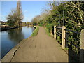
3
Pathway to Dockholme Lock
The Erewash Canal towpath forms part of Sustrans route 67, as indicated by the signs, as well as the Erewash Valley Way and the Nutbrook Trail long distance paths.
Image: © Alan Murray-Rust
Taken: 1 Jan 2018
0.08 miles
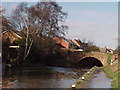
4
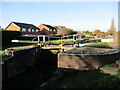
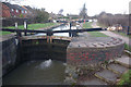
Dockholme Lock. Erewash Canal
Dates from 1779. Listed https://historicengland.org.uk/listing/the-list/list-entry/1204172?section=official-listing
Image: © Jonathan Thacker
Taken: 26 Jan 2022
0.08 miles
5
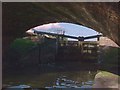
Dockholme Lock
No 62 on the Erewash Canal
Image: © Andrew Abbott
Taken: 28 Dec 2019
0.08 miles
6
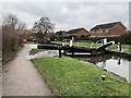
Dockholme Lock, Long Eaton
The third lock up the Erewash Canal from the River Trent, Listed Grade II.
Image: © Alan Murray-Rust
Taken: 1 Jan 2018
0.09 miles
7
Dockholme Lock, Erewash Canal
Seen from Dockholme Bridge
Image: © Tim Glover
Taken: 17 Jan 1999
0.09 miles
8
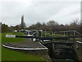
Dockholme Lock, Erewash Canal
As the canal climbs from Long Eaton to Sandiacre it passes between residential districts on the western side and railway land to the east. Along this stretch is Dockholme Lock.
Image: © Stephen McKay
Taken: 1 Jan 2010
0.09 miles
9
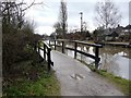
Towpath bridge over overflow weir, between Sandiacre and Dockholme locks
Image: © Christine Johnstone
Taken: 24 Jan 2010
0.09 miles