IMAGES TAKEN NEAR TO
Welbeck Road, NOTTINGHAM, NG10 4GQ
Introduction
This page details the photographs taken nearby to Welbeck Road, NG10 4GQ by members of the Geograph project.
The Geograph project started in 2005 with the aim of publishing, organising and preserving representative images for every square kilometre of Great Britain, Ireland and the Isle of Man.

There are currently over 7.5m images from over14,400 individuals and you can help contribute to the project by visiting https://www.geograph.org.uk
Image Map
Images are licensed for reuse under creativecommons.org/licenses/by-sa/2.0
Notes
- Clicking on the map will re-center to the selected point.
- The higher the marker number, the further away the image location is from the centre of the postcode.
Image Listing (94 Images Found)
Images are licensed for reuse under creativecommons.org/licenses/by-sa/2.0
Image
Details
Distance
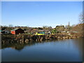
2
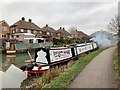
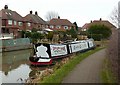
Th'ilson Giant
Canal & River Trust number 53476.
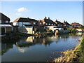
Erewash Canal.
Image: © Andrew Abbott
Taken: 28 Dec 2019
0.07 miles
3
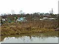
Allotments, Long Eaton
Alongside the Erewash Canal.
Image: © Alan Murray-Rust
Taken: 1 Jan 2018
0.08 miles
4
Th'Ilson Giant, narrowboat
Th'Ilson Giant was Samuel Taylor http://www.geograph.org.uk/photo/5497513 , although the boat is not small either.
(Ilson is the traditional local pronunciation of Ilkeston).
Image: © Alan Murray-Rust
Taken: 1 Jan 2018
0.08 miles
5
Allotments beyond the canal
Looking across the Erewash Canal.
Image: © Jonathan Thacker
Taken: 26 Jan 2022
0.09 miles
6
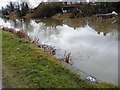
Angler's spot no. 20, Erewash Canal, Sandiacre
The towpath has a long sequence of these numbers, marking locations for anglers during competitions.
Image: © Christine Johnstone
Taken: 24 Jan 2010
0.10 miles
7
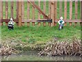
Wallace and Gromit , between the canalside and a back garden fence
The canal is the Erewash, the back garden is in Welbeck Road, Long Eaton.
Image: © Christine Johnstone
Taken: 24 Jan 2010
0.10 miles
8
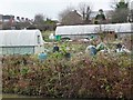
Allotments lying between the Erewash and disused Derby canals
These are very big allotment 'sheds'
Image: © Christine Johnstone
Taken: 24 Jan 2010
0.10 miles
9
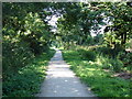
Part of the Derby and Sandiacre Canal
Most of this canal has disappeared, including this section immediately after the junction of the canal with the Erewash canal [http://www.geograph.org.uk/photo/891877]. This short stretch has been filled in and is now a cycle and footpath leading down to Longmoor Lane, about 0.5 km away. The other side of Longmoor Lane the canal has disappeared completely under an housing estate.
Image: © Oxymoron
Taken: 21 Jul 2008
0.13 miles
10
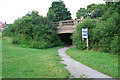
Canal Bridge on Longmoor Road
Now passes over a footpath which follows the line of the Derby and Sandiacre Canal.
Image: © David Lally
Taken: 7 Jul 2008
0.13 miles