IMAGES TAKEN NEAR TO
Bostock Lane, NOTTINGHAM, NG10 4EH
Introduction
This page details the photographs taken nearby to Bostock Lane, NG10 4EH by members of the Geograph project.
The Geograph project started in 2005 with the aim of publishing, organising and preserving representative images for every square kilometre of Great Britain, Ireland and the Isle of Man.

There are currently over 7.5m images from over14,400 individuals and you can help contribute to the project by visiting https://www.geograph.org.uk
Image Map
Images are licensed for reuse under creativecommons.org/licenses/by-sa/2.0
Notes
- Clicking on the map will re-center to the selected point.
- The higher the marker number, the further away the image location is from the centre of the postcode.
Image Listing (26 Images Found)
Images are licensed for reuse under creativecommons.org/licenses/by-sa/2.0
Image
Details
Distance
1
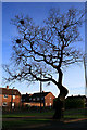
Oak Tree with Rooks' Nests
Longmoor Road, Long Eaton.
This is on the main route into the town from junction 25 on the M1
Image: © David Lally
Taken: 8 Apr 2009
0.02 miles
2
Bungalows on Longmoor Road
These bungalows are located on a small close leading off the main road.
Image: © Oxymoron
Taken: 15 Aug 2008
0.05 miles
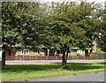
3
Green Space off Longmoor Road
This is an attractive green space fringed by mature trees, but the roads here are very busy - junction 25 of the M1 is very close.
Image: © Oxymoron
Taken: 15 Aug 2008
0.06 miles
4
Derby Canal Walk, Long Eaton
The old Derby canal winds its way around the outskirts of Long Eaton, now made into a path. There are plans to reopen it as a navigable waterway although the M1, just to the west of here, presents a major obstacle.
Image: © Stephen McKay
Taken: 1 May 2016
0.06 miles
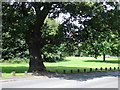
5
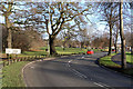
Longmoor Road - Long Eaton
At this bend the B6002 changes from Petersham Road to Longmoor Road.
The Public Open Space formed in the triangle between Longmoor Rd, Bostocks Lane and the M1 forms a pleasant patch of greenery.
Image: © David Lally
Taken: 29 Dec 2007
0.07 miles
6
Towards the Ramada Jarvis
The roof of the hotel by junction 25 on the M1 forms the skyline of this picture.
Image: © David Lally
Taken: 8 Apr 2009
0.07 miles
7
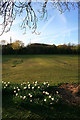
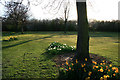
Daffodils in the Evening Sun
On the small open space by Longmoor Road, Long Eaton.
Image: © David Lally
Taken: 8 Apr 2009
0.07 miles
8
Evening Daffodils
On the small open space by Longmoor Road, Long Eaton.
The line of scrub in the background marks both the embankment of the M1 motorway and the line of the Derby and Sandiacre Canal.
Image: © David Lally
Taken: 8 Apr 2009
0.08 miles
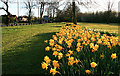
9
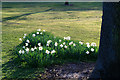
White Daffodils
On the small open space by Longmoor Road, Long Eaton.
Image: © David Lally
Taken: 8 Apr 2009
0.08 miles
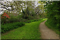
10
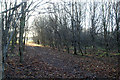
Bridle Path - Long Eaton
This short bridle path passes through a patch of young trees between the end of Petersham Road and Bostocks Lane. A few yards to the west runs the M1 motorway.
Image: © David Lally
Taken: 29 Dec 2007
0.09 miles