IMAGES TAKEN NEAR TO
Haslemere Road, NOTTINGHAM, NG10 4AG
Introduction
This page details the photographs taken nearby to Haslemere Road, NG10 4AG by members of the Geograph project.
The Geograph project started in 2005 with the aim of publishing, organising and preserving representative images for every square kilometre of Great Britain, Ireland and the Isle of Man.

There are currently over 7.5m images from over14,400 individuals and you can help contribute to the project by visiting https://www.geograph.org.uk
Image Map
Images are licensed for reuse under creativecommons.org/licenses/by-sa/2.0
Notes
- Clicking on the map will re-center to the selected point.
- The higher the marker number, the further away the image location is from the centre of the postcode.
Image Listing (144 Images Found)
Images are licensed for reuse under creativecommons.org/licenses/by-sa/2.0
Image
Details
Distance
1
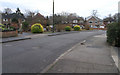
Parkside Avenue - Long Eaton
As Parkside Avenue turns West there is this curious semicircular service road bisected with a straight driveway. Which leaves two quadrant "gardens", well kept with domed privet and cherry trees - but who is responsible for maintaining them?
Image: © David Lally
Taken: 30 Dec 2007
0.08 miles
2
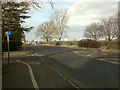
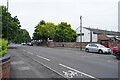
Derby Road, Long Eaton
Leaving Long Eaton, approaching the Wilsthorpe Island (a horrible oval-shaped roundabout).
This is also the A6005
Image: © David Lally
Taken: 7 Mar 2009
0.10 miles
3
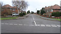
Hillside Drive - Long Eaton
There is a slight incline up this quiet suburban street, it probably rises about 5 feet - that's as near as you will get to a hill in Long Eaton!
Image: © David Lally
Taken: 30 Dec 2007
0.10 miles
4
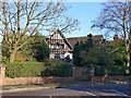
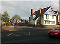
Red Court, Derby Road
A large house in Arts and Crafts style, built 1910 to the design of Osborne Moorhouse Thorpe, and largely unaltered, including at the time of listing most of its original interiors, including some original furniture. Listed Grade II.
Image: © Alan Murray-Rust
Taken: 7 Jan 2018
0.10 miles
5
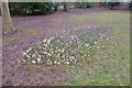
A poor display this year
The crocus are out but not looking happy Image
Image: © David Lally
Taken: 2 Mar 2015
0.11 miles
6
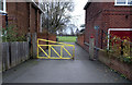
West Park - Parkside Avenue entrance
Sustrans route 6 enters (and leaves) West Park though here.
Image: © David Lally
Taken: 30 Dec 2007
0.12 miles
7
Briar Gate, Long Eaton 1
Briar Gate runs approximately Northward for about three quarters of a mile, from Derby Road to Longmoor Road.
It is fascinating for its slide down the property market as you head North.
At the Derby Road end are some of what must be the most expensive houses in the area. Before the junction with Canal Street each is an individually designed detached with (I'd guess) between 4 and 6 bedrooms, from between 1920 and 1940 (again a guess)
Continued: Image
Image: © David Lally
Taken: 30 Dec 2007
0.12 miles
8
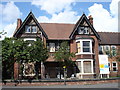
House on Derby Road, Long Eaton
There are a number of impressive houses along this part of Derby Road, but being too big for most modern needs or taste many have been converted into rest homes or other institutions. This example is now closed-up and awaiting the developer's tender attentions.
Image: © Oxymoron
Taken: 21 Aug 2008
0.13 miles
9
Douglas Road, Long Eaton
At its junction with Derby Road.
Image: © David Lally
Taken: 7 Mar 2009
0.13 miles
10
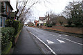
Looking across Derby Road
The view is across the A6005 Derby Road towards Trent College, a public school in Long Eaton.
Image: © Malcolm Neal
Taken: 17 Jun 2021
0.14 miles