IMAGES TAKEN NEAR TO
Pennyfields Boulevard, NOTTINGHAM, NG10 3QJ
Introduction
This page details the photographs taken nearby to Pennyfields Boulevard, NG10 3QJ by members of the Geograph project.
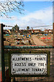
The Geograph project started in 2005 with the aim of publishing, organising and preserving representative images for every square kilometre of Great Britain, Ireland and the Isle of Man.

There are currently over 7.5m images from over14,400 individuals and you can help contribute to the project by visiting https://www.geograph.org.uk
Image Map
Images are licensed for reuse under creativecommons.org/licenses/by-sa/2.0
Notes
- Clicking on the map will re-center to the selected point.
- The higher the marker number, the further away the image location is from the centre of the postcode.
Image Listing (87 Images Found)
Images are licensed for reuse under creativecommons.org/licenses/by-sa/2.0
Image
Details
Distance
1
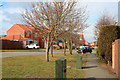
Pennyfield Boulevard
Together with Cranfleet Way this road forms the main thoroughfare of the Wilsthorpe Meadows estate which was started about seven years ago and still has building going on.
Image: © David Lally
Taken: 14 Mar 2010
0.02 miles
2
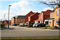
Dunn Drive
On the Wilsthorpe Meadows estate. These houses have been built at least two years now and for all of that time have looked out onto a building site as the area between them and Wilsthorpe Road is filled-in. Progress on the completion of the estate has been slow, probably due to the economic climate.
Image: © David Lally
Taken: 14 Mar 2010
0.06 miles
3
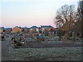
Long Eaton Allotments
Dawn breaks over the allotments on the B6002 at Long Eaton, opposite West Park recreation ground.
Image: © Roger May
Taken: 28 Jan 2006
0.09 miles
4
Wilsthorpe Road Allotments, Long Eaton
View over the main gate into the Wilsthorpe Road Allotments, Long Eaton.
Image: © Clive Cartwright
Taken: 24 Sep 2022
0.09 miles
5
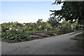
Long Eaton Allotments
Also the subject of the "first" for this square. This appears to a well subscribed and productive area.
Image: © David Lally
Taken: 14 Mar 2010
0.10 miles
6
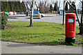
Postbox on Wisthorpe Road
Opposite the main entrance to West Park.
Image: © David Lally
Taken: 14 Mar 2010
0.11 miles
7
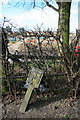
Gas mains marker
Near the entrance to Long Eaton allotments on Wilsthorpe Road.
Image: © David Lally
Taken: 14 Mar 2010
0.11 miles
8
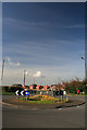
Floral Display on Roundabout on Wilsthorpe Road
Taken from the entrance to the West Park Leisure Centre car park.
Behind is the Wilsthorpe Meadows housing development.
Image: © David Lally
Taken: 5 Apr 2009
0.12 miles
9
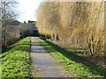
Flood bank alongside Golden Brook
Incorporating a public footpath. The brook used to be subject to severe flooding.
Image: © Alan Murray-Rust
Taken: 7 Jan 2018
0.12 miles
10
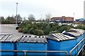
The aftermath of Christmas
Piles of discarded Christmas trees at the West Park Recycling Centre, Long Eaton.
Image: © Alan Murray-Rust
Taken: 1 Jan 2018
0.12 miles