IMAGES TAKEN NEAR TO
Thoresby Road, NOTTINGHAM, NG10 3NP
Introduction
This page details the photographs taken nearby to Thoresby Road, NG10 3NP by members of the Geograph project.
The Geograph project started in 2005 with the aim of publishing, organising and preserving representative images for every square kilometre of Great Britain, Ireland and the Isle of Man.

There are currently over 7.5m images from over14,400 individuals and you can help contribute to the project by visiting https://www.geograph.org.uk
Image Map
Images are licensed for reuse under creativecommons.org/licenses/by-sa/2.0
Notes
- Clicking on the map will re-center to the selected point.
- The higher the marker number, the further away the image location is from the centre of the postcode.
Image Listing (103 Images Found)
Images are licensed for reuse under creativecommons.org/licenses/by-sa/2.0
Image
Details
Distance
1
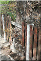
A Gap in the Fence
In a rare moment of municipal consideration a gap in the West Park fence has been left for the trunk of this oak.
Image: © David Lally
Taken: 27 Apr 2008
0.01 miles
2

Galls on Oak Stem
Oak Apples. This Oak on Thoresby Road had lots of them.
However when I returned only a few weeks later to rephotograph them, as I assumed that the colour would change, there were none to be seen.
Image: © David Lally
Taken: 27 Apr 2008
0.02 miles
3
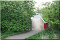
Thoresby Road Entrance to West Park
Hemmed in by newly leafing hawthorn
Image: © David Lally
Taken: 27 Apr 2008
0.02 miles
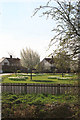
5
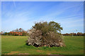
Hedge in West Park
With the blackthorn in blossom.
Image: © David Lally
Taken: 5 Apr 2009
0.04 miles
6
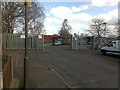
School Gates
The entrance to both Stanton Vale and The Long Eaton Schools. The latter has other, pedestrian only entrance to the east and north east.
Image: © David Lally
Taken: 23 Mar 2009
0.05 miles
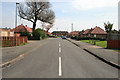
7
Thoresby Road from West Park
Here there is a crescent on the south side of Thoresby Road. With Whitebeams coming into leaf and white daffodils in bloom it looks attractive in the morning sunshine.
Image: © David Lally
Taken: 5 Apr 2009
0.07 miles
8
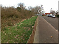
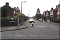
Thoresby Road
Near to the entrance to Stanton Vale and The Long Eaton Schools.
The trees to the left mark the line of the flood defence bank which runs along the entire southern boundary of West Park
Image: © David Lally
Taken: 23 Mar 2009
0.08 miles
9
Laurel Crescent
Not really a crescent this road consists of a straight section leading to a rectangular circuit.
Image: © David Lally
Taken: 27 Apr 2008
0.08 miles
10
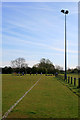
Rugby Pitch Flood Light
This is the only pitch to have lighting in West Park.
Image: © David Lally
Taken: 5 Apr 2009
0.09 miles