IMAGES TAKEN NEAR TO
Hawthorne Avenue, NOTTINGHAM, NG10 3NG
Introduction
This page details the photographs taken nearby to Hawthorne Avenue, NG10 3NG by members of the Geograph project.
The Geograph project started in 2005 with the aim of publishing, organising and preserving representative images for every square kilometre of Great Britain, Ireland and the Isle of Man.

There are currently over 7.5m images from over14,400 individuals and you can help contribute to the project by visiting https://www.geograph.org.uk
Image Map
Images are licensed for reuse under creativecommons.org/licenses/by-sa/2.0
Notes
- Clicking on the map will re-center to the selected point.
- The higher the marker number, the further away the image location is from the centre of the postcode.
Image Listing (74 Images Found)
Images are licensed for reuse under creativecommons.org/licenses/by-sa/2.0
Image
Details
Distance
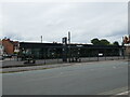
2
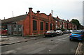
Old Mill Building
Image: © David Lally
Taken: 7 Sep 2008
0.10 miles
3
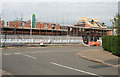
New Houses
Being built on the site of the Derwent Street Mills, a former hosiery factory
Image: © David Lally
Taken: 27 Apr 2008
0.10 miles
5
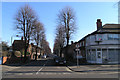
Berkeley Avenue, Long Eaton
A pleasant street of late-Victorian (or Edwardian) semi-detached villas, lined with Lime trees.
Image: © David Lally
Taken: 10 Feb 2008
0.13 miles
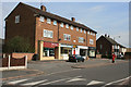
7
New Apartments, Oakland Avenue, Long Eaton
The construction of these apartments was delayed due to the rejection of the initial plans because of an objection on the basis of flood risk by the Environment Agency.
The plans where resubmitted with the elevation of the building and were passed. You can see that this does sit on a small embankment.
Presumably the permission also included the condition that the existing trees along Oakland Avenue were preserved - I'm sure given half the chance a developer would have felled them to make construction easier.
Image: © David Lally
Taken: 10 Feb 2008
0.13 miles

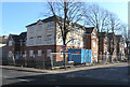
9
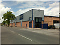
New Self-Storage Units
In the end a tiny bit of character of the old mill remains see http://www.geograph.org.uk/photo/955929 and http://www.geograph.org.uk/photo/697715.
Image: © David Lally
Taken: 20 May 2009
0.14 miles