IMAGES TAKEN NEAR TO
Ruskin Avenue, NOTTINGHAM, NG10 3HY
Introduction
This page details the photographs taken nearby to Ruskin Avenue, NG10 3HY by members of the Geograph project.
The Geograph project started in 2005 with the aim of publishing, organising and preserving representative images for every square kilometre of Great Britain, Ireland and the Isle of Man.

There are currently over 7.5m images from over14,400 individuals and you can help contribute to the project by visiting https://www.geograph.org.uk
Image Map
Images are licensed for reuse under creativecommons.org/licenses/by-sa/2.0
Notes
- Clicking on the map will re-center to the selected point.
- The higher the marker number, the further away the image location is from the centre of the postcode.
Image Listing (69 Images Found)
Images are licensed for reuse under creativecommons.org/licenses/by-sa/2.0
Image
Details
Distance
1
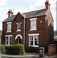
House on Ruskin Avenue, New Sawley
New Sawley is sandwiched between the railway line, the M1 motorway, and the B6002 (Wilsthorpe Road). This attractive older house is typical of the houses closer to the main road (Wilsthorpe Road); further along the road (towards the motorway) the housing is much more modern.
Image: © Oxymoron
Taken: 15 Aug 2008
0.07 miles
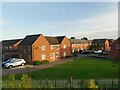
2
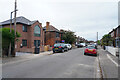
Carlton Road
The first house on the left seems to have had a very good extension or redesign, with the huge triangular topped window above the main entrance.
Image: © Malcolm Neal
Taken: 17 Jun 2021
0.11 miles
3
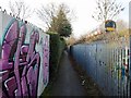
Footpath by the railway
This was originally a field path to Sawley but urbanisation and diversions have left it hemmed-in and subject to vandalism and anti-social behaviour.
Image: © Ian Calderwood
Taken: 7 Dec 2016
0.13 miles
4
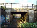
Railway bridge over a footpath
This was originally a farm access but the footpath was diverted this way to avoid a level crossing in the early 20th century.
Image: © Ian Calderwood
Taken: 7 Dec 2016
0.14 miles
5
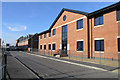
New offices of the Three Valleys Housing Association
This Association now administers all ex-council housing in the Borough of Erewash.
The factory which stood here until recently was presumably originally involved in the lace, or other textile, industry. Latterly it was a depot for Brakes - the food distributor.
Image: © David Lally
Taken: 10 Feb 2008
0.14 miles
7
Houses beside Long Eaton railway station
Image: © Chris Morgan
Taken: 25 Sep 2020
0.15 miles
8
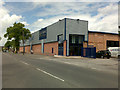
New Self-Storage Units
In the end a tiny bit of character of the old mill remains see http://www.geograph.org.uk/photo/955929 and http://www.geograph.org.uk/photo/697715.
Image: © David Lally
Taken: 20 May 2009
0.16 miles
9
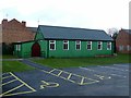
Church of St Mary, Sawley
Constructed as a Chapel of Ease for the parish of All Saints, this is the only remaining 'tin tabernacle' still in use as a place of worship in the Diocese of Derby. It was presented by the parish of Heanor as a temporary building in 1912 and has recently passed its centenary. After refurbishment in 2013 it is good for quite a few years more.
Image: © Alan Murray-Rust
Taken: 1 Jan 2018
0.16 miles
10
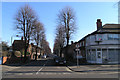
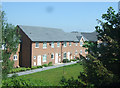
Berkeley Avenue, Long Eaton
A pleasant street of late-Victorian (or Edwardian) semi-detached villas, lined with Lime trees.
Image: © David Lally
Taken: 10 Feb 2008
0.16 miles