IMAGES TAKEN NEAR TO
River View, NOTTINGHAM, NG10 3AR
Introduction
This page details the photographs taken nearby to River View, NG10 3AR by members of the Geograph project.
The Geograph project started in 2005 with the aim of publishing, organising and preserving representative images for every square kilometre of Great Britain, Ireland and the Isle of Man.

There are currently over 7.5m images from over14,400 individuals and you can help contribute to the project by visiting https://www.geograph.org.uk
Image Map
Images are licensed for reuse under creativecommons.org/licenses/by-sa/2.0
Notes
- Clicking on the map will re-center to the selected point.
- The higher the marker number, the further away the image location is from the centre of the postcode.
Image Listing (126 Images Found)
Images are licensed for reuse under creativecommons.org/licenses/by-sa/2.0
Image
Details
Distance
1
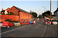
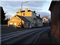
Tamworth Road is Closed
For the whole of August '09 due to the flood protection work. As can be seen pedestrian access is being maintained; this evening I observed a few motorbikes taking advantage of the gap as well.
Image: © David Lally
Taken: 7 Aug 2009
0.02 miles
2
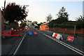
Tamworth Road is Closed
Looking back toward the Harrington Arms. The road is closed for flood defence work, throughout August 2009.
Image: © David Lally
Taken: 7 Aug 2009
0.02 miles
3
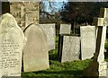
Gravestones in Sawley churchyard
Including a selection of extremely finely incised slate panels of the mid 19th century.
Image: © Alan Murray-Rust
Taken: 7 Jan 2018
0.03 miles
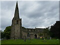
6

Church of All Saints, Sawley
The end of the south aisle. This shows signs of two stages of construction. The later part is 14th century decorated, the earlier 13th century, with lancet window and a much steeper roof, possibly continuous with that of the nave.
Image: © Alan Murray-Rust
Taken: 7 Jan 2018
0.03 miles
7
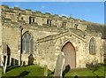
Church of All Saints, Sawley
The south aisle, porch and clerestory. The aisle with reticulated window tracery is probably 14th century, the clerestory is 15th century Perpendicular and the shallow angle of the porch roof suggest a similar date. However, there is evidence of a porch with a much steeper roof line, and therefore earlier.
Image: © Alan Murray-Rust
Taken: 7 Jan 2018
0.03 miles
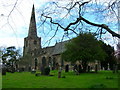
8
All Saints' church, Sawley
Medieval church built between the eleventh and fifteenth centuries https://historicengland.org.uk/listing/the-list/list-entry/1204277?section=official-list-entry
Image: © Jonathan Thacker
Taken: 4 Aug 2024
0.03 miles
10
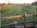
Stile at Sawley leading back to the Trent
Image: © Andy Jamieson
Taken: 2 Jan 2009
0.03 miles