IMAGES TAKEN NEAR TO
Co-Operative Street, NOTTINGHAM, NG10 1FP
Introduction
This page details the photographs taken nearby to Co-Operative Street, NG10 1FP by members of the Geograph project.
The Geograph project started in 2005 with the aim of publishing, organising and preserving representative images for every square kilometre of Great Britain, Ireland and the Isle of Man.

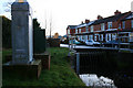
There are currently over 7.5m images from over14,400 individuals and you can help contribute to the project by visiting https://www.geograph.org.uk
Image Map
Images are licensed for reuse under creativecommons.org/licenses/by-sa/2.0
Notes
- Clicking on the map will re-center to the selected point.
- The higher the marker number, the further away the image location is from the centre of the postcode.
Image Listing (38 Images Found)
Images are licensed for reuse under creativecommons.org/licenses/by-sa/2.0
Image
Details
Distance
1
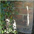
Bench mark, Oakley's Road, Long Eaton
See http://www.geograph.org.uk/photo/5658516 for location.
Image: © Alan Murray-Rust
Taken: 19 Jan 2018
0.08 miles
2
Electricity substation, Oakley's Road, Long Eaton
There is a bench mark http://www.geograph.org.uk/photo/5658514 on the brick wall by the hedge on the left.
Image: © Alan Murray-Rust
Taken: 19 Jan 2018
0.09 miles
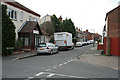
3
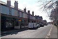
Oakley's Road in Long Eaton
Pictured here on a pleasant Saturday afternoon in early April.
Image: © Jonathan Clitheroe
Taken: 6 Apr 2013
0.09 miles
4
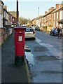
E VII R pillar box, Craig Street, Long Eaton Ref NG10 16
Several of the adjacent houses have datestones from the early years of the 20th century.
Image: © Alan Murray-Rust
Taken: 19 Jan 2018
0.10 miles
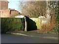
5
Culvert for Golden Brook
Adjacent to Oakley's Road, this culvert carries the brook under the roundabout on Main Street.
Image: © David Lally
Taken: 17 Jan 2009
0.15 miles
6
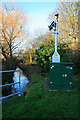
Water Monitoring Station
On Golden Brook adjacent to Oakley's Road.
This is about a kilometre downstream of the similar monitor situated as the brook leaves West Park http://www.geograph.org.uk/photo/981075. It is about to enter a short culvert which will take it under the Main Street roundabout.
Image: © David Lally
Taken: 17 Jan 2009
0.15 miles
8
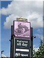
The Tappers Harker
Inn sign for this pub https://www.geograph.org.uk/photo/7222054 . The choice of a Great Western Railway train as illustration, in what was a stronghold of the Midland Railway, is classic inattention to local detail!
Image: © Alan Murray-Rust
Taken: 8 Jul 2022
0.19 miles
9

14 and 16 Main Street, Long Eaton
14 is Jordan House, occupied by the Canaan Trust
Image: © Andrew Abbott
Taken: 24 May 2020
0.20 miles
10
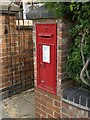
Main Street postbox DE55 340
VR wall box with narrow slot, built into a brick pillar.
Image: © Alan Murray-Rust
Taken: 8 Jul 2022
0.20 miles