1
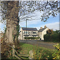
Junction of Fairlea Close and Manchester Street, Long Eaton
The view is from a footpath out of Collingwood Road Recreation Ground
Image The modest houses are dwarfed by a magnificent Wych Elm (Ulmus glabra).
Image: © Robin Stott
Taken: 18 Nov 2017
0.02 miles
2
Parking and a football match at Collingwood Road Recreation Ground, Long Eaton
On a sunny Saturday morning in November. The ground, at the end of Cornwallis Close, is managed by Erewash Borough Council. There are some good trees here.
Image: © Robin Stott
Taken: 18 Nov 2017
0.08 miles
3
St Francis of Assisi RC Church
On Tamworth Road.
Image: © David Lally
Taken: 30 Aug 2008
0.11 miles
4
Church of St Francis of Assisi, Tamworth Road
Roman Catholic parish church, dating from around 1900.
There is a bench mark http://www.geograph.org.uk/photo/5643510 on the house at the left hand side of the picture.
Image: © Alan Murray-Rust
Taken: 1 Jan 2018
0.12 miles
5
Erewash Canal alongside Tamworth Road
There is a bench mark http://www.geograph.org.uk/photo/5643506 on the upper surface of the low wall bottom right.
Image: © Alan Murray-Rust
Taken: 1 Jan 2018
0.12 miles
6
Bench mark alongside the canal, Long Eaton
See http://www.geograph.org.uk/photo/5643507 for location.
Image: © Alan Murray-Rust
Taken: 1 Jan 2018
0.12 miles
7
Erewash Canal alongside Tamworth Road
The footbridge gives (private) access to Long Eaton School.
Image: © Alan Murray-Rust
Taken: 1 Jan 2018
0.12 miles
8
The canal by Tamworth Road
The canal is part of the Erewash canal and runs down to Trent Lock.
Image: © Malcolm Neal
Taken: 17 Jun 2021
0.13 miles
9
Bench mark, 197 Tamworth Road, Long Eaton
See http://www.geograph.org.uk/photo/5643513 for location.
Image: © Alan Murray-Rust
Taken: 1 Jan 2018
0.13 miles
10
The Barge Inn, Long Eaton
This pub, overlooking the Erewash Canal, is painted a very lurid shade - whoever could have thought this was a good idea? Of course, no boater would ever refer to a canal narrowboat as a 'barge', so it is to be hoped that the name refers only to the customers' usual mode of entry.
Image: © Stephen McKay
Taken: 1 Jan 2010
0.13 miles


