IMAGES TAKEN NEAR TO
Queen Street, NOTTINGHAM, NG10 1BJ
Introduction
This page details the photographs taken nearby to Queen Street, NG10 1BJ by members of the Geograph project.
The Geograph project started in 2005 with the aim of publishing, organising and preserving representative images for every square kilometre of Great Britain, Ireland and the Isle of Man.

There are currently over 7.5m images from over14,400 individuals and you can help contribute to the project by visiting https://www.geograph.org.uk
Image Map
Images are licensed for reuse under creativecommons.org/licenses/by-sa/2.0
Notes
- Clicking on the map will re-center to the selected point.
- The higher the marker number, the further away the image location is from the centre of the postcode.
Image Listing (286 Images Found)
Images are licensed for reuse under creativecommons.org/licenses/by-sa/2.0
Image
Details
Distance
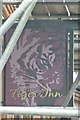
2
The Tiger Inn
On Tamworth Road. Been closed a while don't know if the scaffolding marks its demise as a pub or not. Used to feature frequently in the CAMRA Good Beer Guide.
Image: © David Lally
Taken: 5 Mar 2017
0.05 miles
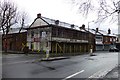
3
Tiger Inn
Former Good Beer Guide listed pub on Tamworth Road Long Eaton.
Image: © David Lally
Taken: 25 Apr 2011
0.05 miles
4
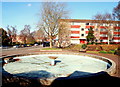
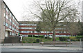
Romorantin Place, Long Eaton, Derbys.
A glance across this mid-60s Square shows traffic on Tamworth Road (the B6540) heading towards Market Place with a glimpse of the Library Gardens beyond it. The square and the housing complex that overlooks it on two sides was so named to commemorate the 1961 town-twinning partnership with Romorantin-Lanthenay in the Loire Valley, an arrangement that stemmed initially from contacts between the rugby clubs of these two towns. Unfortunately one of the two residential blocks has been empty for the last 2-3 years.
Image: © David Hallam-Jones
Taken: 17 Feb 2013
0.05 miles
5
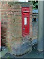
Postbox and bench mark, Tamworth Road
VR wall box in a brick pillar at the junction of Queen Street. The bench mark is below the postbox.
Image: © Alan Murray-Rust
Taken: 19 Jan 2018
0.06 miles
6
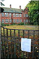
Planning Notice, Long Eaton School
About two and a half years after the school was vacated a planning notice finally turns up.
A company is requesting permission to convert the ground floor of the West Wing (which cannot be seen here) into Offices - It would appear from the details of the application that the conversion will be very sympathetic to the Grade II listed building and hopefully signals its survival.
Image: © David Lally
Taken: 7 Sep 2008
0.06 miles
8
Flats on Tamworth Road
The nearest thing to a 1960's towerblock you get in Long Eaton.
Image: © David Lally
Taken: 27 Apr 2008
0.06 miles
9
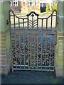
Gateway at the former Long Eaton School, Tamworth Road
Classic Art Nouveau style; the school was built in 1911. See http://www.geograph.org.uk/photo/5648382 .
Image: © Alan Murray-Rust
Taken: 7 Jan 2018
0.06 miles
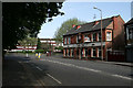
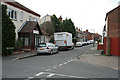
10
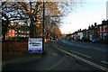
Tamworth Road, Long Eaton
Looking toward the town centre. The old Long Eaton Grammar School building on the left.
Image: © David Lally
Taken: 28 Dec 2008
0.07 miles