IMAGES TAKEN NEAR TO
Michaelmas Street, GATESHEAD, NE8 2GP
Introduction
This page details the photographs taken nearby to Michaelmas Street, NE8 2GP by members of the Geograph project.
The Geograph project started in 2005 with the aim of publishing, organising and preserving representative images for every square kilometre of Great Britain, Ireland and the Isle of Man.

There are currently over 7.5m images from over14,400 individuals and you can help contribute to the project by visiting https://www.geograph.org.uk
Image Map
Images are licensed for reuse under creativecommons.org/licenses/by-sa/2.0
Notes
- Clicking on the map will re-center to the selected point.
- The higher the marker number, the further away the image location is from the centre of the postcode.
Image Listing (127 Images Found)
Images are licensed for reuse under creativecommons.org/licenses/by-sa/2.0
Image
Details
Distance
1
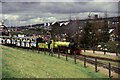
National Garden Festival, Gateshead - steam railway
The positions and direction are a best guess. This whole site has been extensively built over and there are few things left to orientate this. The three pitched roofs are on the Tyneside Heritage exhibition that was near the start of the coal staithes. This section of line was definitely in the area of the festival known as Dunston after crossing over the river Team. This also appears to be the start of the loop as the track is branched here. The locomotive is a narrow gauge engine from the Ravenglass and Eskdale Railway and is called Northern Rock. The festival also had a monorail and a tram but locating them on the map is probably beyond me.
Image: © Chris Allen
Taken: 30 Jul 1990
0.01 miles
2

Gardens and houses on Michaelmas Street
Seen from the Dunston Staithes Railway Path.
Image: © Oliver Dixon
Taken: 19 Sep 2017
0.02 miles
3
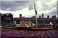
National Garden Festival, Gateshead - Reliant paddle tug
A large replica of the Reliant steam paddle tug that used to be on display at the National Maritime Museum but has been scrapped. The Dunston Coal Staiths are in the background with the Tyneside Heritage exhibition on the left. This site has since been built on and the positions are best guesses.
Image: © Chris Allen
Taken: 30 Jul 1990
0.03 miles
4
The Lambton Worm at the Gateshead Garden Festival
Image: © Steve Daniels
Taken: 5 Aug 1990
0.04 miles
5

The courses of two railway lines south of Dunston Staiths
For information about the coal staiths, see Image
The right hand line served the upper stages of the staiths - see Image from where the coal was loaded into ships via chutes - see Image The left hand line curved round to the right (at more or less the same level as here) to link with lines running along the riverside near the Image
Image: © Mike Quinn
Taken: 5 Sep 2018
0.04 miles
6

The course of the railway line to the upper level of Dunston Staiths
For information about the coal staiths, see Image
Image: © Mike Quinn
Taken: 5 Sep 2018
0.04 miles
7

Dunston Staithes Upper Gate
A railway (now converted to a cycle path) used to run through this gate. The apartment blocks are on the far side of the River Tyne.
Image: © Oliver Dixon
Taken: 19 Sep 2017
0.05 miles
8

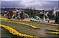
National Garden Festival, Gateshead
Seen from Dunston Coal Staiths. The smoke on the left is from the replica Locomotion on the Stockton Birthplace of Railways exhibition. The positions are approximate.
The impressive 29 storey tower block is Derwent Tower, also known as the Dunston Rocket. This was opened in 1971 and demolished in 2012.
Image: © Chris Allen
Taken: 30 Jul 1990
0.05 miles
9

Footbridge over the River Team
The bridge is on the course of the old railway to Dunston Staiths Image . The location of the bridge is also shown in Image
Image: © Mike Quinn
Taken: 5 Sep 2018
0.05 miles
10

Dunston Staithes crossing the Keelman's Way
An amazing piece of industrial archaeology beside the mouth of the River Team where it enters the Tyne.
Image: © Oliver Dixon
Taken: 19 Sep 2017
0.05 miles