IMAGES TAKEN NEAR TO
Kirknewton, WOOLER, NE71 6XP
Introduction
This page details the photographs taken nearby to NE71 6XP by members of the Geograph project.
The Geograph project started in 2005 with the aim of publishing, organising and preserving representative images for every square kilometre of Great Britain, Ireland and the Isle of Man.

There are currently over 7.5m images from over14,400 individuals and you can help contribute to the project by visiting https://www.geograph.org.uk
Image Map
Images are licensed for reuse under creativecommons.org/licenses/by-sa/2.0
Notes
- Clicking on the map will re-center to the selected point.
- The higher the marker number, the further away the image location is from the centre of the postcode.
Image Listing (19 Images Found)
Images are licensed for reuse under creativecommons.org/licenses/by-sa/2.0
Image
Details
Distance
1
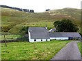
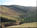
Trowupburn
A small cottage and farm buildings in the valley of the Trowup Burn, west of the College Valley.
It is likely that the farm takes its name from the stream valley, and I had a feeling that the earlier spelling of the place name may have been 'Trowhope Burn', as 'hope' is a common term in the locality for flat land in a valley. However, the first edition OS (1861) records 'Trough Burn' and the farm as 'Troughburn'. By 1897, it had become 'Trowup Burn' as it is today.
Image: © Andrew Curtis
Taken: 28 Sep 2012
0.00 miles
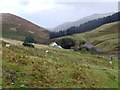
4
Trowupburn from the south-west ridge of Great Hetha
Similar view to Image
Image: © Andrew Curtis
Taken: 28 Sep 2012
0.01 miles
5
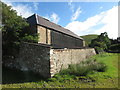
Farm Outbuilding, Trowupburn
This outbuilding, which is open fronted, was in all likelihood originally constructed as a cart shed. It stands to the south of the farmhouse. For a selection of detailed free to download walking routes in the area visit www.cheviotwalks.co.uk
Image: © Geoff Holland
Taken: 28 Jul 2020
0.02 miles
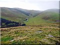
7
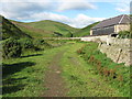
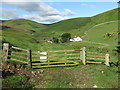
Public Footpath, Trowupburn
This footpath, which links the College Valley with Trowupburn, is about to pass the outbuildings of this isolated and beautifully situated farm. The conical hill in the distance is Shorthope Shank. For a selection of detailed free to download walking routes in the area visit www.cheviotwalks.co.uk
Image: © Geoff Holland
Taken: 28 Jul 2020
0.04 miles
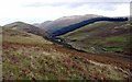
8
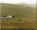
Trowupburn.
Looking SW over this grid square. The main hill on the skyline is "Saughieside" a remote and difficult hill to attain. (by Cheviot standards)
Image: © Hill Walker
Taken: 6 Apr 2006
0.04 miles
9
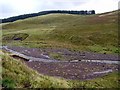
Flood erosion in Trowup Burn
A flash flood, after a recent heavy rain storm, has washed down lots of gravel through which the normally placid burn now runs in changing channels. There is also a small landslide showing further downstream where a bend in the burn has washed away the bank.
Image: © Andrew Curtis
Taken: 28 Sep 2012
0.10 miles
10
Gate Near Trowupburn
This gate marks the boundary between the plantation covering Sinkside Hill, which is currently in the course of harvesting https://www.geograph.org.uk/photo/6552941, and the open countryside surrounding the isolated farm of Trowupburn, seen ahead. For a selection of detailed free to download walking routes in the area visit www.cheviotwalks.co.uk
Image: © Geoff Holland
Taken: 28 Jul 2020
0.12 miles