IMAGES TAKEN NEAR TO
Kirknewton, WOOLER, NE71 6XH
Introduction
This page details the photographs taken nearby to NE71 6XH by members of the Geograph project.
The Geograph project started in 2005 with the aim of publishing, organising and preserving representative images for every square kilometre of Great Britain, Ireland and the Isle of Man.

There are currently over 7.5m images from over14,400 individuals and you can help contribute to the project by visiting https://www.geograph.org.uk
Image Map
Images are licensed for reuse under creativecommons.org/licenses/by-sa/2.0
Notes
- Clicking on the map will re-center to the selected point.
- The higher the marker number, the further away the image location is from the centre of the postcode.
Image Listing (21 Images Found)
Images are licensed for reuse under creativecommons.org/licenses/by-sa/2.0
Image
Details
Distance
1
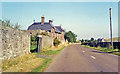
Former Kirknewton station, 1991
View eastward on B6351, towards Wooler and Alnwick: ex-NER Alnwick - Wooler - Coldstream line. The station (on left, long since converted to a private house), last saw passengers 22/9/30, goods 30/3/53. Wooler - Coldstream closed finally from 29/3/65, after Wooler - Ilderton had been severed earlier and Alnwick - Ilderton closed 2/3/53.
Image: © Ben Brooksbank
Taken: 6 Sep 1991
0.01 miles
2
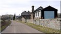
Kirknewton Railway Station
The former railway station, comprising Station Master's House, station and signal box stands on the North Eastern Railway line from Alnwick to Wooler and Cornhill which opened in 1887. The station buildings are of red sandstone. It was turned into a house after the line closed in 1953, having already closed to passengers 20 years earlier.
http://ads.ahds.ac.uk/catalogue/search/fr.cfm?rcn=NSMR03-2120
Image: © Andrew Curtis
Taken: 5 Mar 2010
0.06 miles
3
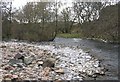
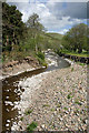
College Burn & Bowmont Water
College Burn & Bowmont Water meet to form the River Glen, this flows into the River Till then River Tweed.
Follow Bowmont Water Image
Image: © Hill Walker
Taken: 16 Apr 2006
0.06 miles
4
College Burn
In the centre is one of the abutments that carried the bridge of the old Alnwick & Cornhill Railway before it was washed away.
In the distance is Watch Hill.
Image: © Russel Wills
Taken: 8 Mar 2016
0.07 miles
5
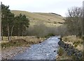
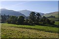
The College Burn
This is a view downstream from Westnewton Bridge towards Lanton Hill.
Image: © Walter Baxter
Taken: 14 May 2011
0.08 miles
6
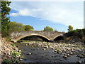
College Burn at Westnewton Bridge
Westnewton Bridge was built in the late 18th or early 19th century. It has seven arches in all, four of which are small flood arches. It is a Grade II Listed Building protected by law.
Keys to the Past: http://www.keystothepast.info/article/10339/site-Details?PRN=N2059
The small flood arches are now largely blocked by earth and rubble.
Historic England (List Entry Number: 1042320) https://historicengland.org.uk/listing/the-list/list-entry/1042320
Image: © Andrew Curtis
Taken: 10 Oct 2003
0.09 miles
7
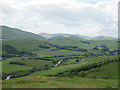
The valley of the River Glen
A view of this beautiful valley from Lanton Hill.
This photograph was taken during a 'socially-distanced' period of exercise during the Coronavirus (COVID-19) pandemic of 2020.
Image: © James T M Towill
Taken: 20 Jun 2020
0.13 miles
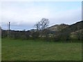
8
View into the Cheviots
Looking over the Glen towards Newton Tors. The "kame" is an old railway embankment on the Cornhill Branch.
Image: © Richard Webb
Taken: 29 Sep 2015
0.13 miles
9
Embankment and track bed of the old Alnwick & Cornhill Railway
Housdon Hill is just right of centre.
Image: © Russel Wills
Taken: 8 Mar 2016
0.14 miles
10
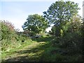
Cornhill Branch trackbed
East of the site of Kirknewton Station. Passenger services stopped in 1930.
Image: © Richard Webb
Taken: 29 Sep 2015
0.16 miles