IMAGES TAKEN NEAR TO
WOOLER, NE71 6QT
Introduction
This page details the photographs taken nearby to NE71 6QT by members of the Geograph project.
The Geograph project started in 2005 with the aim of publishing, organising and preserving representative images for every square kilometre of Great Britain, Ireland and the Isle of Man.

There are currently over 7.5m images from over14,400 individuals and you can help contribute to the project by visiting https://www.geograph.org.uk
Image Map
Images are licensed for reuse under creativecommons.org/licenses/by-sa/2.0
Notes
- Clicking on the map will re-center to the selected point.
- The higher the marker number, the further away the image location is from the centre of the postcode.
Image Listing (8 Images Found)
Images are licensed for reuse under creativecommons.org/licenses/by-sa/2.0
Image
Details
Distance
1
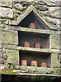
No Doos!
The flight holes in this small dovecote in a farm building at Lilburn Hill have been closed up with bricks.
Image: © Lisa Jarvis
Taken: 22 Apr 2007
0.01 miles
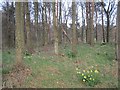
2
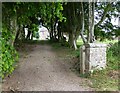
The drive to Lilburn Hill
An old avenue of trees.
Image: © Russel Wills
Taken: 18 Jun 2015
0.02 miles
3
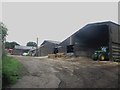
Farm buildings at Lilburn Hill
A range of farm buildings on the roadside forming part of the steading at Lilburn Hill.
Image: © Graham Robson
Taken: 5 Jul 2015
0.02 miles
5
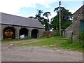
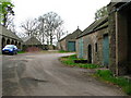
Lilburn Hill
Old farm buildings, the start of a public footpath and an electricity pole.
Image: © Russel Wills
Taken: 18 Jun 2015
0.04 miles
8
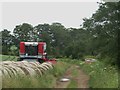
Farm track, Lilburn Hill
A farm track leading away to further fields from Lilburn Hill farm. A Massey Ferguson combine harvester is hibernating beside a row of round bales on the field margin. The track is also a bridleway.
Image: © Graham Robson
Taken: 5 Jul 2015
0.18 miles