IMAGES TAKEN NEAR TO
North Bank, BELFORD, NE70 7HA
Introduction
This page details the photographs taken nearby to North Bank, NE70 7HA by members of the Geograph project.
The Geograph project started in 2005 with the aim of publishing, organising and preserving representative images for every square kilometre of Great Britain, Ireland and the Isle of Man.

There are currently over 7.5m images from over14,400 individuals and you can help contribute to the project by visiting https://www.geograph.org.uk
Image Map (Loading...)


Getting Data...Please wait
Leaflet Map data © OpenStreetMap
Images are licensed for reuse under creativecommons.org/licenses/by-sa/2.0
Notes
- Clicking on the map will re-center to the selected point.
- The higher the marker number, the further away the image location is from the centre of the postcode.
Image Listing (23 Images Found)
Images are licensed for reuse under creativecommons.org/licenses/by-sa/2.0
Image
Details
Distance
1
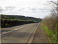
Looking down North Bank out of Belford
Looking north down North Bank out of Belford. The road was formerly the A1 before the bypass was built to the east of the village in the early 1980s.
Image: © Graham Robson
Taken: 24 Apr 2013
0.04 miles
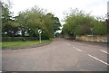
2
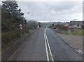
North Bank
Looking along North Bank outside of Belford. The road was formerly the A1.
Image: © DS Pugh
Taken: 7 Aug 2019
0.05 miles
3
Down the hill into Belford
Travelling into Belford on a cold grey day.
Image: © Barbara Carr
Taken: 21 Mar 2013
0.05 miles
4
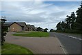
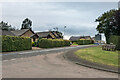
Outskirts of Belford
Looking at some of the houses on top of the hill.
Image: © DS Pugh
Taken: 12 Aug 2013
0.07 miles
5
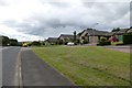
North Bank
1980s/90s bungalows on North Bank, the former A1 but now C58 following the bypassing of Belford in 1983.
Image: © Ian Capper
Taken: 28 Sep 2020
0.08 miles
6
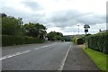
Road descending to Belford
Looking down the hill towards Belford.
Image: © DS Pugh
Taken: 7 Aug 2019
0.08 miles
8
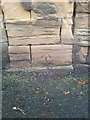
OS Cut Mark - North Bank, Belford
B01481 - OS Cut Mark: Belford, North Bank
Image: © thejackrustles
Taken: 15 Sep 2014
0.11 miles
9
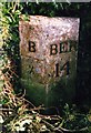
Old Milepost by the former A1, north of Belford
Metal post with attached metal plate by the UC road (was A1), in parish of BELFORD (BERWICK UPON TWEED District), North Bank, back of bank by path, on East side of road. B/BER bevel iron casting, erected by the Berwick, Norham & Islandshires turnpike trust in the 19th century.
Inscription reads:- : B / ½ : : BER / 14 :
Milestone Society National ID: NB_BWBF14.
Image: © IA Davison
Taken: 23 Oct 2004
0.12 miles
10
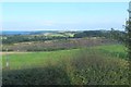
Looking across Cragmill Quarry to Budle Bay
Cragmill Quarry is just north of Belford.
Image: © Barbara Carr
Taken: 7 Sep 2013
0.14 miles