IMAGES TAKEN NEAR TO
CHATHILL, NE67 5JA
Introduction
This page details the photographs taken nearby to NE67 5JA by members of the Geograph project.
The Geograph project started in 2005 with the aim of publishing, organising and preserving representative images for every square kilometre of Great Britain, Ireland and the Isle of Man.

There are currently over 7.5m images from over14,400 individuals and you can help contribute to the project by visiting https://www.geograph.org.uk
Image Map
Images are licensed for reuse under creativecommons.org/licenses/by-sa/2.0
Notes
- Clicking on the map will re-center to the selected point.
- The higher the marker number, the further away the image location is from the centre of the postcode.
Image Listing (26 Images Found)
Images are licensed for reuse under creativecommons.org/licenses/by-sa/2.0
Image
Details
Distance
1
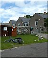
Ice creams for sale
Ice creams were for sale (£1/each) here operating on an honesty box system.
Image: © DS Pugh
Taken: 26 Jun 2022
0.01 miles
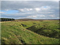
3
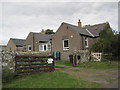
Botany
A remote dwelling between North Charlton and Chillingham.
Image: © Russel Wills
Taken: 17 Aug 2015
0.02 miles
4
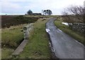
Bridge over tributary to Harehope Burn
Botany on the skyline.
Image: © Russel Wills
Taken: 9 Feb 2013
0.02 miles
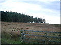
5
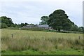
Moorland at Borany
A small farm is located here, with self-service ice creams for sale beside the road.
Image: © DS Pugh
Taken: 26 Jun 2022
0.04 miles
6
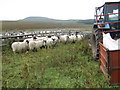
Botany; sheep about to be shorn
Waiting in the pens for their turn to have long winter coats chopped. The shearers were working by the other side of the tractor. The prominent feature in the distance is Ros Hill.
Image: © Jonathan Billinger
Taken: 18 Jul 2007
0.07 miles
7
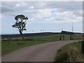
Road and farmland, Botany
Green fields amongst the moors courtesy of exposed limestone. Northumberland seems to be catching up with Berwickshire in the scenery trashing game. Some very fine areas of fell sandstone to the north around Bowden Doors are threatened by subsidy harvesting wind farmers at this time.
Image: © Richard Webb
Taken: 17 May 2014
0.07 miles
8
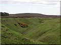
Quarry workings, Botany
Coal measures limestone is exposed here and was quarried for lime which was required to sweeten the usual acid soils found on the fell sandstone nearby.
Image: © Richard Webb
Taken: 17 May 2014
0.09 miles
9
Disused Quarry near Botany
To the right in the dip are bee hives.
Image: © Les Hull
Taken: 11 Sep 2012
0.09 miles
10
Forest near Botany, Hepburn Moor
On the road from Chillingham to the A1.
Image: © Kirsty Smith
Taken: 12 Nov 2005
0.09 miles