IMAGES TAKEN NEAR TO
CHATHILL, NE67 5HG
Introduction
This page details the photographs taken nearby to NE67 5HG by members of the Geograph project.
The Geograph project started in 2005 with the aim of publishing, organising and preserving representative images for every square kilometre of Great Britain, Ireland and the Isle of Man.

There are currently over 7.5m images from over14,400 individuals and you can help contribute to the project by visiting https://www.geograph.org.uk
Image Map
Images are licensed for reuse under creativecommons.org/licenses/by-sa/2.0
Notes
- Clicking on the map will re-center to the selected point.
- The higher the marker number, the further away the image location is from the centre of the postcode.
Image Listing (11 Images Found)
Images are licensed for reuse under creativecommons.org/licenses/by-sa/2.0
Image
Details
Distance
1
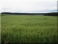
Arable field at Wandylaw
A large arable field at Wandylaw. A crop of oats is currently ripening on the land.
Image: © Graham Robson
Taken: 12 Jul 2014
0.04 miles
2
Wandylaw Farm
From the footpath to the east; the 1940s map has "Windy Law". Note the chimney, a common feature of farms in this area.
Image: © Dave Dunford
Taken: 13 Apr 2006
0.05 miles
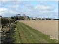
3
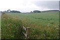
Wandylaw from the west
View east along the bridleway.
Image: © Dave Dunford
Taken: 13 Apr 2006
0.05 miles
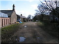
4
Farm cottages at Wandylaw
This range of cottages at Wandylaw are the original accommodation attached to the farm for workers. They probably no longer house many farm workers however as the buildings of the farm steading have all been converted into residential accommodation. As often seems to be the case in this area there are large wind turbines lurking in the background.
Image: © Graham Robson
Taken: 12 Jul 2014
0.08 miles
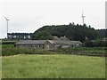
5
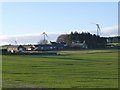
Wandylaw
With some of the wind turbines of Middlemoor Wind Farm beyond.
Image: © Russel Wills
Taken: 8 Jan 2014
0.09 miles
7

Road, Wandylaw
Heading along the edge of arable land towards Wandylaw Dean.
Image: © Richard Webb
Taken: 29 Jul 2016
0.15 miles
8
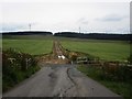
Track across arable field at Wandylaw
This track across an arable field to the north of Wandylaw was built to enable construction traffic for Wandylaw Wind Farm to avoid the narrow section of road around the houses at Wandylaw. After completion of the development the wide, well made stone surface has been removed.
Image: © Graham Robson
Taken: 12 Jul 2014
0.16 miles
9
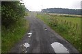
Road, Wandylaw
Heading for Wandylaw Moor, now home to turbines.
Image: © Richard Webb
Taken: 29 Jul 2016
0.17 miles
10
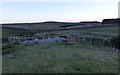
Washpool
Marked so on the map but what to wash? Sheep?
Image: © Russel Wills
Taken: 8 Jan 2014
0.24 miles