IMAGES TAKEN NEAR TO
Old Bewick, ALNWICK, NE66 4EE
Introduction
This page details the photographs taken nearby to NE66 4EE by members of the Geograph project.
The Geograph project started in 2005 with the aim of publishing, organising and preserving representative images for every square kilometre of Great Britain, Ireland and the Isle of Man.

There are currently over 7.5m images from over14,400 individuals and you can help contribute to the project by visiting https://www.geograph.org.uk
Image Map
Images are licensed for reuse under creativecommons.org/licenses/by-sa/2.0
Notes
- Clicking on the map will re-center to the selected point.
- The higher the marker number, the further away the image location is from the centre of the postcode.
Image Listing (15 Images Found)
Images are licensed for reuse under creativecommons.org/licenses/by-sa/2.0
Image
Details
Distance
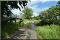
1
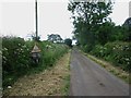
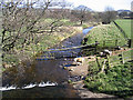
Approaching the ford across Lilburn Burn
Approaching the ford across Lilburn Burn from the north this road sign warns of the water flowing across the road. The text on the bottom of the two signs reads "Dangerous when Flooded".
Image: © Graham Robson
Taken: 7 Jul 2014
0.06 miles
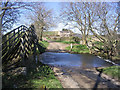
2
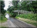
Lilburn Burn Ford
Lilburn Burn crosses the country road to the north of East Lilburn via this ford. A footbridge has been built to the right to allow pedestrians to cross dry footed.
Image: © Graham Robson
Taken: 7 Jul 2014
0.09 miles
3
Ford at East Lilburn
Unsurprisingly through the Lilburn Burn.
Image: © Russel Wills
Taken: 9 Feb 2013
0.09 miles
4
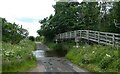
Ford and bridge
Looking along the road to East Lilburn.
Image: © DS Pugh
Taken: 26 Jun 2022
0.09 miles
5
Ford through Lilburn Burn
Looking along the road to Newtown with a bridge beside the ford.
Image: © DS Pugh
Taken: 26 Jun 2022
0.09 miles
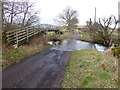
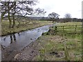
6
Ford at Lilburn Burn
A small ford with a footbridge on the left. Newtown Mill is in the background.
Image: © Walter Baxter
Taken: 5 Apr 2007
0.09 miles
7
Lilburn Ford
This ford on the Lilburn Burn is found on the approach to Newtown Mill.
Image: © John Walton
Taken: 7 May 2014
0.10 miles
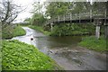
9
Lilburn Burn
Viewed from the footbridge at the ford south of Newtown Mill.
Image: © Walter Baxter
Taken: 5 Apr 2007
0.12 miles
10
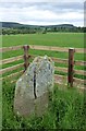
Standing stone on Ewe Hill
The stone is beside the course of Devil's Causeway - a Roman road.
In the distance is Bewick Hill which has a number of carved stones and could be linked.
Image: © Russel Wills
Taken: 18 Jun 2015
0.16 miles